All countries of the world listed from A-Z:

or choose from the countries per continent below:


 |  |  |  |  |  |
 | PITCAIRNgeneral data of the country |
| General useful information |
| Note: some data are of constant value, while other are due to changes, fluctuations etc. |
| Nation and population |
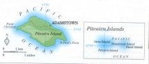
| official name (short form): Pitcairn Islands |
| country code ISO: PN //; - FIPS: PC |
| location: South Pacific Ocean |
| time zone: -8:30 UT |
| surface (land) area (of the total group): 47,3 sq.km = 18.3 sq.mi |
| geographical position in extreme co-ordinates: North/South: 24° S / East/West: 129° W |
| borders (land): none |
| borders (coastline): Pacific Ocean |
| climate: subtropical oceanic |
| Government |
| independent since: not yet |
| type of government: colonial territory within the British Commonwealth |
| capital: Adamstown |
| administrative division: none, or unknown |
| Population |
| population according to the latest census (1991): 66 |
| total population according to the estimate of midyear 1995: 54 / - ; 2000: 44 |
| population density: 1 per sq.km = 2,6 per sq.mi |
| population growth: % //; - doubling time: not applicable, stable or declining population |
| birth rate: per 1000 |
| death rate: per 1000 |
| fertility rate: children per female |
| maternal mortality: per 100,000 |
| infant mortality (1-4 years): per 1000 |
| life expectancy: years (male: ; female: ) |
| age breakdown: 0-14 years: % //; - 15-59 years: % //; - 60+ years: % |
| urbanisation: 90% [if the only settlement is regarded a city] //; - urbanisation growth: 0% |
| percentage of urban population in the greatest city: 100% |
| Ethnic composition, language, religion |
| ethnic groups: of British descent |
| languages: English |
| religious affiliation: unknown |
| Health |
| daily food intake: calories per capita |
| population with access to safe water: % |
| people per physician: |
| people per hospital bed: |
| Education, literacy |
| school enrolment: primary education 6-11 years: % |
| school enrolment: secondary education: % |
| school enrolment: tertiary education 20-24 years: % |
| adult literacy: % (male: %; female: %) |
| Economy and infrastructure |
| Economy and trade |
| currency: |
| annual inflation rate: % |
| population below poverty line: % |
| Gross Domestic Product: USD per capita |
| GNI USD per capita //; - [ppp: ] |
| GDP growth: % |
| income: USD per capita |
| import: USD per capita //; - export: USD per capita |
| trade: USD per capita //; - or % of GDP |
| trade partners: |
| human development index: //; - position of the country in the world no.: |
| female labour force: % |
| unemployment: % |
| tourism: million |
| Economic activities in agriculture, fisheries, industry, mining, services, energy |
| land use: arable land: % //; - grass land: % //; - wooded area: % //; - arid land and desert: % |
| agriculture: labour force: % //; - part of agriculture in GDP: % |
| agricultural products: fruit (oranges, pineapples), vegetables |
| livestock (1000s): asses: / buffaloes: / camels: / cattle: / goats: / horses: / mules: / pigs: / poultry: / sheep: |
| fish catch: metric tonnes |
| industry: labour force: % //; - part of industry in GDP: % |
| industrial products: none, or unknown |
| mining products: none, or unknown |
| CO2 emission per capita: |
| services: labour force: % //; - part of services in GDP: % |
| energy use (kg per capita): |
| electricity use (per capita): |
| annual water use (per capita): |
| Traffic, communication |
| road network: km //; - of which paved: % //; - of which are motorways: km |
| vehicles: per 1000 |
| railways: km //; - railways passenger/km: |
| navigable inland waterways: km |
| ownership telephone: per 1000 |
| ownership radio receivers: per 1000 |
| ownership tv-sets: per 1000 |
| newspaper circulation: per 1000 |
| persons per post office: |
| personal computers: per 1000 |
| Some physical landmarks |
| mountains: nameless peaks - of 335, 299 and 280 m - on Pitcairn Island; details are not available at the compiler |
| lowest point: sea level |
| lakes (natural): none, or unknown |
| lakes (artificial reservoirs): none, or unknown |
| lakes (deepest): unknown |
| rivers: none, or unknown // canals: none, or unknown |
| waterfalls: none, or unknown // caves: longest system: none, or unknown / deepest: |
| islands: Ducie, Henderson, Oeno (all annexed in 1902) and Pitcairn |
| deserts: none |
| other natural features: |
| Additional remarks, especially on the statistical information |
| other important features: |
| apart from physical landmarks most of the above figures are changeable, in most cases they date from the 1990's |
| discovered 1767 by Philip Carteret; remained unhabited until 1790; occupied by 9 mutineers of H.M.S. Bounty > |
| with 12 women and 6 men from Tahiti; nothing was known of their existence until the island was visited again in 1808 |
| primary sources used for the general information: |
| BB CA EV PW WA WB WR, and some national statistical yearbooks |
| particulars concerning population data: |
| In 1856 the population having become too large for the island's resources, the inhabitants were, |
| at their own request, removed to Norfolk Island; but 43 of them returned in the years 1859-1864 |
 To the page containing the population growth statistics of the country
 To the page containing some information on the islands
There is only one settlement in this country, called Adamstown; source CA states a population of 53 inhabitants in 1993; no detailed historical data are available of this town.
 Back to the homepage of this website: POPULATION STATISTICS
Latest modification of this page on 2004-03-02 by Jan Lahmeyer
© "populstat" site: Jan Lahmeyer