All countries of the world listed from A-Z:

or choose from the countries per continent below:


 |  |  |  |  |  |
 | MICRONESIA[Federated States of Micronesia, FSM] : general data of the country |
| General useful information |
| Note: some data are of constant value, while other are due to changes, fluctuations etc. |
| Nation and population |
| official name (short form): Micronesia |
| country code ISO: FM //; - FIPS: FM |
| location: West Pacific |
| time zone: +10 to + 11 UT |
| surface (land) area: 701,4 sq.km = 270,8 sq.mi //; - area incl. inland waters: sq.km = sq.mi |
| geographical position in extreme co-ordinates: North: 13° N / South: 0° N / East: 168° E / West: 136° E |
| borders (land): none |
| borders (coastline): Pacific Ocean |
| climate: tropical oceanic |
| Government |
| independent since: 1979 ; 1990-12-22 |
| type of government: republic |
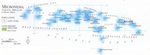
| capital: Palikir, Pohnpei, or: Kolonia |
| administrative division: island group (4) |
| Population |
| population according to the latest census (2000): 107,008 |
| total population according to the estimate of midyear 2000: 133,144; or: 118,000; 2001: 109,000 |
| population density: 154 per sq.km = 399 per sq.mi |
| population growth: 3% //; - doubling time: 24 years |
| birth rate: 27 - 29 per 1000 |
| death rate: 6 -7 per 1000 |
| fertility rate: 5 children per female |
| maternal mortality: per 100,000 |
| infant mortality (1-4 years): 49 per 1000 |
| life expectancy: 68 years (male: 67; female: 71) |
| age breakdown: 0-14 years: 41% //; - 15-59 years: 52% //; - 60+ years: 7% |
| urbanisation: 28% //; - urbanisation growth: % |
| percentage of urban population in the greatest city: % |
| Ethnic composition, language, religion |
| ethnic groups: Trukese 41%; Pophpeian 26%; Mortlockese 8%; Kosraean 7%; Yapese 6%; Ulithian 4% |
| languages: English, local Micronesian and Polynesian languages like Trukese, Pohnpeian, Yapese |
| religious affiliation: Roman Catholic 41%; Protestant 37%; other 22% |
| Health |
| daily food intake: calories per capita |
| population with access to safe water: 100% |
| people per physician: 1677 |
| people per hospital bed: 260 |
| Education, literacy |
| school enrolment: primary education 6-11 years: 75% |
| school enrolment: secondary education: 18% |
| school enrolment: tertiary education 20-24 years: 8% |
| adult literacy: 77% (male: 67%; female: 87%) [later total figure found: 94%] |
| Economy and infrastructure |
| Economy and trade |
| currency: US dollar = 100 cents |
| annual inflation rate: 2,6% |
| population below poverty line: % |
| Gross Domestic Product: USD 1890 per capita |
| GNI USD 2110 per capita //; - [ppp: 1830] |
| GDP growth: -1% |
| income: USD 1500 per capita |
| import: USD 129 per capita //; - export: USD 78 per capita |
| trade: USD 700 per capita //; - or % of GDP |
| trade partners: EU US |
| human development index: //; - position of the country in the world no.: |
| female labour force: 47% |
| unemployment: % |
| tourism: 0,003 million |
| Economic activities in agriculture, fisheries, industry, mining, services, energy |
| land use: arable land: 34% //; - grass land: 14% //; - wooded area: 23% //; - arid land and desert: % |
| agriculture: labour force: 20% //; - part of agriculture in GDP: 42% |
| agricultural products: coconuts, copra, fish (tuna), cassava, sweet potatoes, peppers, tropical fruits, black pepper |
| livestock (1000s): cattle: 14 / goats: 4 / poultry: 185 / sheep: 32 |
| fish catch: metric tonnes |
| industry: labour force: 0% //; - part of industry in GDP: 0% |
| industrial products: some food & fish processing, only of local importance |
| mining products: none |
| CO2 emission per capita: |
| services: labour force: 80% //; - part of services in GDP: 58% |
| energy use (kg per capita): 40 |
| electricity use (per capita): |
| annual water use (per capita): |
| Traffic, communication |
| road network: 226 km //; - of which paved: 18% //; - of which are motorways: 0 km |
| vehicles: ? per 1000 |
| railways: 0 km //; - railways passenger/km: - |
| navigable inland waterways: 0 km |
| ownership telephone: 74 - 80 per 1000 |
| ownership radio receivers: 667 per 1000 |
| ownership tv-sets: 21 per 1000 |
| newspaper circulation: per 1000 |
| persons per post office: |
| personal computers: per 1000 |
| Some physical landmarks |
| mountains: Totolom 791 m, Nanlaud 772, Dolohniwar 760, Finol (Mt.Crozer?) 634, Mount Buache 593 |
| lowest point: sea level |
| lakes (natural): some inner lakes of atolls |
| lakes (artificial reservoirs): none, or unknown |
| lakes (deepest): unknown |
| rivers: only a few short rivers to drain the mountains |
| canals: none, or unknown |
| waterfalls: none, or unknown |
| caves: longest system: none, or unknown / deepest: |
| islands: see the separate file of the administrative divsion |
| deserts: none |
| other natural features: |
| Additional remarks, especially on the statistical information |
| other important features: |
| apart from physical landmarks most of the above figures are changeable, in most cases they date from the 1990's |
| partly formerly known as Caroline Islands, which included Palau and excluded Yap |
| primary sources used for the general information: |
| BB CA EV PW WA WB WR, and some national statistical yearbooks |
| particulars concerning population data: |
 To the page containing the population growth statistics of the country
 To the page containing the historical population growth statistics of the provinces
 To the page containing urban historical population statistics
 Back to the homepage of this website: POPULATION STATISTICS
Latest modification of this page on 2004-02-26 by Jan Lahmeyer
© "populstat" site: Jan Lahmeyer