All countries of the world listed from A-Z:

or choose from the countries per continent below:


 |  |  |  |  |  |
 | LIECHTENSTEINgeneral data of the country |
| General useful information |
| Note: some data are of constant value, while other are due to changes, fluctuations etc. |
| Nation and population |
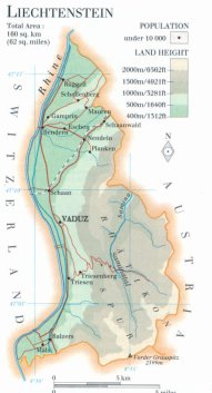
| official name (short form): Liechtenstein |
| country code ISO: LI //; - FIPS: LS |
| location: Central Europe |
| time zone: +1 UT* [*= applying daylight saving time] |
| surface (land) area: 160 sq.km = 62 sq.mi //; - area incl. inland waters: sq.km = sq.mi |
| geographical position in extreme co-ordinates: North: 47°16'14" N / South: 47°02'54" N / East: 9°38'08" E / West: 9°28'18" E |
| borders (land): total 76 km: in the east with Austria (35 km) and in the west with Switzerland (41 km) |
| borders (coastline): none |
| climate: mild continental |
| Government |
| independent since: 1719 ; 1806-07-12 |
| type of government: principality |
| capital: Vaduz |
| administrative division: region (2) into commune (11) |
| Population |
| population according to the latest census (1990): 29,032 |
| total population according to the estimate of midyear 2000: 32,207 / -; 2001: 32,863 |
| population density: 201 per sq.km = 521 per sq.mi |
| population growth: 1% //; - doubling time: not applicable, exceeds 100 years |
| birth rate: 11 - 13 per 1000 |
| death rate: 6 - 7per 1000 |
| fertility rate: 2 children per female |
| maternal mortality: 0 per 100,000 |
| infant mortality (1-4 years): 5,5 per 1000 |
| life expectancy: 78 years (male: 75; female: 83) |
| age breakdown: 0-14 years: 19% //; - 15-59 years: 67% //; - 60+ years: 14% |
| urbanisation: 22 - 28% //; - urbanisation growth: % |
| percentage of urban population in the greatest city: % |
| Ethnic composition, language, religion |
| ethnic groups: Alemannic 88 - 95%; plus Swiss, Austrian, German, Italian, Turkic, Yugoslav minorities |
| languages: German (official); Alemannic dialect |
| religious affiliation: Roman Catholic 79%; Protestant 8%; other 13% |
| Health |
| daily food intake: 3531 calories per capita |
| population with access to safe water: virtually 100% |
| people per physician: 714 |
| people per hospital bed: 288 |
| Education, literacy |
| school enrolment: primary education 6-11 years: 100% |
| school enrolment: secondary education: % |
| school enrolment: tertiary education 20-24 years: 0% [in this country there are no higher education facilities available] |
| adult literacy: 100% (male: %; female: %) |
| Economy and infrastructure |
| Economy and trade |
| currency: Swiss franc = 100 Rappen |
| annual inflation rate: 4% |
| population below poverty line: % |
| Gross Domestic Product: USD per capita |
| GNI USD 23000 per capita //; - [ppp: ] |
| GDP growth: -0,2% |
| income: USD 33000 per capita |
| import: USD 906 per capita //; - export: USD 1818 per capita |
| trade: USD per capita //; - or % of GDP |
| trade partners: EU and EFTA countries |
| human development index: //; - position of the country in the world no.: |
| female labour force: 38% |
| unemployment: 4% |
| tourism: 0,061 million |
| Economic activities in agriculture, fisheries, industry, mining, services, energy |
| land use: arable land: 25% //; - grass land: 38% //; - wooded area: 19% //; - arid land and desert: % |
| agriculture: labour force: 2% //; - part of agriculture in GDP: 9% |
| agricultural products: dairy products, grain, corn/maize, potatoes, timber |
| livestock (1000s): cattle: 5-6 / goats: 0,3 / pigs: 2-3 / poultry: 45 / sheep: 3 |
| fish catch: metric tonnes |
| industry: labour force: 34% //; - part of industry in GDP: 32% |
| industrial products: chemicals, furniture, ceramic dentures, precision instruments, textiles, electronics |
| mining products: none |
| CO2 emission per capita: |
| services: labour force: 63% //; - part of services in GDP: 59% |
| energy use (kg per capita): 3126 |
| electricity use (per capita): |
| annual water use (per capita): |
| Traffic, communication |
| road network: 323 km //; - of which paved: 100% //; - of which are motorways: 0 km |
| vehicles: 603 per 1000 |
| railways: 19 km //; - railways passenger/km: - |
| navigable inland waterways: 26 km |
| ownership telephone: 573 - 609 per 1000 |
| ownership radio receivers: 384 - 669 per 1000 |
| ownership tv-sets: 343 - 469 per 1000 |
| newspaper circulation: 581 per 1000 |
| persons per post office: |
| personal computers: per 1000 |
| Some physical landmarks |
| mountains: Vorder Grauspitz 2599 m, Schwarzhorn 2574, Naafkopf 2570, Falknis 2560, Falknishorn 2452 |
| lowest point: 430 m (Ruggeller Riet) |
| lakes (natural): none |
| lakes (artificial reservoirs): none |
| lakes (deepest): not applicable |
| rivers: Rhein (Rhine), Samina |
| canals: none |
| waterfalls: unknown |
| caves: longest system: none, or unknown / deepest: |
| islands: none |
| deserts: none |
| other natural features: |
| Additional remarks, especially on the statistical information |
| other important features: |
| apart from physical landmarks most of the above figures are changeable, in most cases they date from the 1990's |
| some figures [e.g. economical] are not separately available, in that case they are combined with data of Switzerland |
| primary sources used for the general information: |
| BB CA EV PW WA WB WR, and some national statistical yearbooks |
| particulars concerning population data: |
 To the page containing the population growth statistics of the country
 To the page containing the historical population growth statistics of the provinces
NB: The page containing data of urban historical population statistics has been combined into the page of the administrative division
 Back to the homepage of this website: POPULATION STATISTICS
Internet website:Latest modification of this page on 2004-02-22 by Jan Lahmeyer
© "populstat" site: Jan Lahmeyer