All countries of the world listed from A-Z:

or choose from the countries per continent below:


 |  |  |  |  |  |
 | IRELAND [Éire]general data of the country |
| General useful information |
| Note: some data are of constant value, while other are due to changes, fluctuations etc. |
| Nation and population |
| official name (short form): Éire |
| country code ISO: IE //; - FIPS: EI |
| location: West Europe |
| time zone: 0 UT* [*= applying daylight saving time] |
| surface (land) area: 70285 sq.km = 27137 sq.mi //; - area incl. inland waters: sq.km = sq.mi |
| geographical position in extreme co-ordinates: North: 55° N / South: 51° N / East: 6° W / West: 11° W |
| borders (land): Northern Ireland (United Kingdom) |
| borders (coastline): Atlantic Ocean, Celtic Sea, Irish Sea |
| climate: temperate maritime, and in general humid |
| Government |
| independent since: 1921-12-06 |
| type of government: republic |
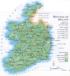
| capital: Baile Átha Cliath [Dublin] |
| administrative division: province (4) into county (26) |
| Population |
| population according to the latest census (1996): 3621,035; or: 3626,087 |
| total population according to the estimate of midyear 2000: 3797,257; or: 3794,000; 2001: 3828,000 |
| population density: 54 per sq.km = 140 per sq.mi |
| population growth: 0,5% //; - doubling time: possibly close to 100 years |
| birth rate: 13 - 15 per 1000 |
| death rate: 8 - 9 per 1000 |
| fertility rate: 2 children per female |
| maternal mortality: 6 per 100,000 |
| infant mortality (1-4 years): 8 per 1000 |
| life expectancy: 77 years (male: 74; female: 80) |
| age breakdown: 0-14 years: 28% //; - 15-59 years: 60% //; - 60+ years: 14% |
| urbanisation: 59% //; - urbanisation growth: 2% |
| percentage of urban population in the greatest city: 50% |
| Ethnic composition, language, religion |
| ethnic groups: Irish 97%; English 2% |
| languages: English, Irish Gealic (both official) |
| religious affiliation: Roman Catholic 92%; Anglican (Church of Ireland) 2,3%; Presbyterian 0,4% |
| Health |
| daily food intake: 3622 calories per capita |
| population with access to safe water: virtually almost 100% |
| people per physician: 457 |
| people per hospital bed: 301 |
| Education, literacy |
| school enrolment: primary education 6-11 years: 100% |
| school enrolment: secondary education: 43% |
| school enrolment: tertiary education 20-24 years: 13% |
| adult literacy: virtually 100% (male: %; female: %) |
| Economy and infrastructure |
| Economy and trade |
| currency: 100 cents (until 2002: Irish pound [punt] = 100 pence) |
| annual inflation rate: 3,5% |
| population below poverty line: 15% |
| Gross Domestic Product: USD 15000 per capita |
| GNI USD 22660 per capita //; - [ppp: 25520] |
| GDP growth: 6,5% |
| income: USD 11000 per capita |
| import: USD 35768 per capita //; - export: USD 48153 per capita |
| trade: USD 14305 per capita //; - or 139% of GDP |
| trade partners: GB US DE JP FR NL |
| human development index: 0,916 //; - position of the country in the world no.: 18 |
| female labour force: 31% |
| unemployment: 4% |
| tourism: 6,7 million |
| Economic activities in agriculture, fisheries, industry, mining, services, energy |
| land use: arable land: 13,4% //; - grass land: 68% //; - wooded area: 4,6% //; - arid land and desert: % |
| agriculture: labour force: 13% //; - part of agriculture in GDP: 11% |
| agricultural products: meat, dairy products, cereals, potatoes, vegetables, peat, fish, sugar beets, turnips |
| livestock (million): asses: 0,01 / cattle: 6,7 / horses: 0,07 / pigs: 1,8 / poultry: 11,8 / sheep: 5,4 |
| fish catch: 285921 - 329496 metric tonnes |
| industry: labour force: 18% //; - part of industry in GDP: 9% |
| industrial products: machinery, textiles, chemicals, food processing, brewing, crystals |
| mining products: gypsum, zinc, lead, natural gas, baryte, copper |
| CO2 emission per capita: 10,3 |
| services: labour force: 69% //; - part of services in GDP: 80% |
| energy use (kg per capita): 3726 |
| electricity use (per capita): 5011 |
| annual water use (per capita): 233 |
| Traffic, communication |
| road network: 92340, or 95835 km //; - of which paved: 94% //; - of which are motorways: 103 km |
| vehicles: 223 per 1000 |
| railways: 1947 km //; - railways passenger/km: 1332 |
| navigable inland waterways: 429 km |
| ownership telephone: 365 - 478 per 1000 |
| ownership radio receivers: 697 per 1000 |
| ownership tv-sets: 283 - 457 per 1000 |
| newspaper circulation: 170 per 1000 |
| persons per post office: 1860 |
| personal computers: 359 - 405 per 1000 |
| Some physical landmarks |
| mountains: Carrauntoohill 1041 m, Cahir 973, Brandon Mt. 953, Percy's Table [Lugnaquilla] 927, Galtymore 919 |
| lowest point: sea level |
| lakes (natural): Lough Corib, Lough Derg, Lough Ree, Lough Mask, Lough Conn |
| lakes (artificial reservoirs): none, or unknown |
| lakes (deepest): unknown |
| rivers: Shannon, Blackwater, Boyne, Suir, Lee, Slaney, Nore |
| canals: Royal Canal |
| waterfalls: none, or unknown |
| caves: longest system: none, or unknown / deepest: |
| islands: Achill Island, Aran Islands |
| deserts: none |
| other natural features: |
| Additional remarks, especially on the statistical information |
| other important features: |
| apart from physical landmarks most of the above figures are changeable, in most cases they date from the 1990's |
| primary sources used for the general information: |
| BB CA EV PW WA WB WR, and some national statistical yearbooks |
| particulars concerning population data: |
 To the page containing the population growth statistics of the country
 To the page containing the historical population growth statistics of the provinces
 To the page containing urban historical population statistics
 Back to the homepage of this website: POPULATION STATISTICS
Internet website: Internet website:Latest modification of this page on 2004-02-18 by Jan Lahmeyer
© "populstat" site: Jan Lahmeyer