All countries of the world listed from A-Z:

or choose from the countries per continent below:


 |  |  |  |  |  |
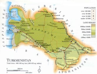 | TURKMENISTANgeneral data of the country |
| General useful information |
| Note: some data are of constant value, while other are due to changes, fluctuations etc. |
| Nation and population |
| official name (short form): Tûrkmenistan |
| country code ISO: TM //; - FIPS: TX |
| location: West Central Asia |
| time zone: +5 UT |
| surface (land) area: 488100 sq.km = 188455 sq.mi //; - area incl. inland waters: sq.km = sq.mi |
| geographical position in extreme co-ordinates: North: 43° N / South: 35° N / East: 67° E / West: 53° E |
| borders (land): Kazakhstan, Uzbekistan, Afghanistan, Iran |
| borders (coastline): Caspian Sea |
| climate: continental arid |
| Government |
| independent since: 1991-10-27 |
| type of government: republic |
| capital: A`'sgabat |
| administrative division: welayah [=province] (4) + city (1) |
| Population |
| population according to the latest census (1995): 4000,460; or: 4483,251 |
| total population according to the estimate of midyear 2000: 4518,268; or: 5199,000 /-; 2001: 4603,244; or: 5170,000 |
| population density: 9,3 per sq.km = 24 per sq.mi |
| population growth: 2,6% //; - doubling time: 29 years |
| birth rate: 29 - 32 per 1000 |
| death rate: 8 - 9 per 1000 |
| fertility rate: 4 children per female |
| maternal mortality: per 100,000 |
| infant mortality (1-4 years): 46 per 1000 |
| life expectancy: 61 - 65 years (male: 57 - 62; female: 65 - 69) |
| age breakdown: 0-14 years: 41% //; - 15-59 years: 53% //; - 60+ years: 6% |
| urbanisation: 45% //; - urbanisation growth: % |
| percentage of urban population in the greatest city: % |
| Ethnic composition, language, religion |
| ethnic groups: Turkmen 77%; Uzbek 9,2%; Russian 6,7%; Kazak 2%; Armenian 0,8%; Ukrainian 0,8%; Tatar 0,8%; Azerbaijan 0,8% |
| languages: Turkmen (official); Russian, Uzbek |
| religious affiliation: Sunnî Muslim 87% (source PW states here: Shî'îte Muslim!); Christian (Eastern Orthodox) 2,5% |
| Health |
| daily food intake: 2684 calories per capita |
| population with access to safe water: 58% |
| people per physician: 330 |
| people per hospital bed: 97 |
| Education, literacy |
| school enrolment: primary education 6-11 years: % |
| school enrolment: secondary education: % |
| school enrolment: tertiary education 20-24 years: % |
| adult literacy: % (male: 98%; female: 97%) |
| Economy and infrastructure |
| Economy and trade |
| currency: Manat = 100 tenesi |
| annual inflation rate: 408% |
| population below poverty line: % |
| Gross Domestic Product: USD 1270 per capita |
| GNI USD 750 per capita //; - [ppp: 3800] |
| GDP growth: -8% |
| income: USD 1700 per capita |
| import: USD 1364 per capita //; - export: USD 1881 per capita |
| trade: USD 350 per capita //; - or 93% of GDP |
| trade partners: CIS-countries TR IR |
| human development index: 0,73 //; - position of the country in the world no.: 83 |
| female labour force: 46% |
| unemployment: 3% |
| tourism: 0,3million |
| Economic activities in agriculture, fisheries, industry, mining, services, energy |
| land use: arable land: 3% //; - grass land: 62% //; - wooded area: 8% //; - arid land and desert: 25% |
| agriculture: labour force: 43% //; - part of agriculture in GDP: 43% |
| agricultural products: seed cotton, vegetables, grain, fruit |
| livestock (1000s): asses: 24 / camels: 40 / cattle: 850 / goats: 368 / horses: 16 / pigs: 46 / poultry: 4550 / sheep: 5600 |
| fish catch: metric tonnes |
| industry: labour force: 11% //; - part of industry in GDP: 41% |
| industrial products: metal & metalworks, food products, chemical products, construction materials, textiles |
| mining products: sulphur, sodium sulphate, potassium, salt, natural oil & gas, coal |
| CO2 emission per capita: 5,7 |
| services: labour force: 47% //; - part of services in GDP: 16% |
| energy use (kg per capita): 2677 |
| electricity use (per capita): 944 |
| annual water use (per capita): 6390 |
| Traffic, communication |
| road network: 22600, or 24000 km //; - of which paved: 81% //; - of which are motorways: 0 km |
| vehicles: 46 per 1000 |
| railways: 2187, or 2393 km //; - railways passenger/km: 2100 |
| navigable inland waterways: 0 km |
| ownership telephone: 82 - 215 per 1000 |
| ownership radio receivers: 189 - 289 per 1000 |
| ownership tv-sets: 189 - 240 per 1000 |
| newspaper circulation: per 1000 |
| persons per post office: |
| personal computers: per 1000 |
| Some physical landmarks |
| mountains: Gora Reza 2942 m, Gora Masinev 2335, Gora Tagarev 2246 |
| lowest point: 26 m below sea level, at the border of the Caspian Sea |
| lakes (natural): Caspian Sea, including Zaliv Kara Bogaz-Gol |
| lakes (artificial reservoirs): none, or unknown |
| lakes (deepest): Caspian Sea |
| rivers: Amu Darya, Atrak |
| canals: Karakumskiy Kanal |
| waterfalls: none, or unknown |
| caves: longest system: none, or unknown / deepest: |
| islands: none |
| deserts: Kara Kum |
| other natural features: |
| Additional remarks, especially on the statistical information |
| other important features: |
| apart from physical landmarks most of the above figures are changeable, in most cases they date from the 1990's |
| primary sources used for the general information: |
| BB CA EV PW WA WB WR, and some national statistical yearbooks |
| particulars concerning population data: |
 To the page containing the population growth statistics of the country
 To the page containing the historical population growth statistics of the provinces
 To the page containing urban historical population statistics
 Back to the homepage of this website: POPULATION STATISTICS
Internet website: Internet website:Latest modification of this page on 2004-03-12 by Jan Lahmeyer
© "populstat" site: Jan Lahmeyer