All countries of the world listed from A-Z:

or choose from the countries per continent below:


 |  |  |  |  |  |
 | OMANgeneral data of the country |
| General useful information |
| Note: some data are of constant value, while other are due to changes, fluctuations etc. |
| Nation and population |
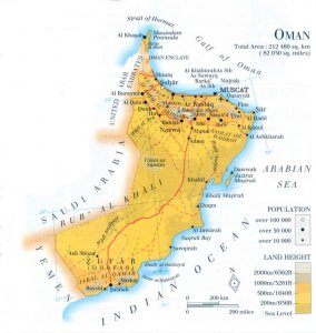
| official name (short form): Oman |
| country code ISO: OM //; - FIPS: MU |
| location: Southwest Asia |
| time zone: +4 UT |
| surface (land) area: 212460 sq.km = 82030 sq.mi //; - area incl. inland waters: 306000 sq.km = 118150 sq.mi |
| geographical position in extreme co-ordinates: North: 26°20' N / South: 16°40' N / East: 59°40' E / West: 51°50' E |
| borders (land): United Arab Emirates, Saudi Arabia, Yemen |
| borders (coastline): Gulf of Oman, Arabian Sea (parts of Indian Ocean) |
| climate: tropical arid |
| Government |
| independent since: 1650 ; 1951-12-20 |
| type of government: absolute monarchy (sultanate) |
| capital: Masqat |
| administrative division: mintaqah = region (6), muhafazat = province (2) |
| Population |
| population according to the latest census (1993): 2017,591, or: 2018,074 |
| total population according to the estimate of midyear 2000: 2533,389; or: 2395,000 / -; 2001: 2623,000 |
| population density: 8,5 - 11 per sq.km = 22 - 29 per sq.mi |
| population growth: 3,9% //; - doubling time: 21 years |
| birth rate: 38 - 44 per 1000 |
| death rate: 4 -5 per 1000 |
| fertility rate: 7 children per female |
| maternal mortality: per 100,000 |
| infant mortality (1-4 years): 30 per 1000 |
| life expectancy: 72 years (male: 70; female: 74) |
| age breakdown: 0-14 years: 47% //; - 15-59 years: 49% //; - 60+ years: 4% |
| urbanisation: 13, or 83% //; - urbanisation growth: % |
| percentage of urban population in the greatest city: % |
| Ethnic composition, language, religion |
| ethnic groups: Omani Arab 73%; Indian 13%; Pakistani (mostly Balochî) 7%; Egyptian 2%; other 5% |
| languages: Arabic (official); Balochî, English |
| religious affiliation: Ibâdiyah Muslim 74%; other Muslim minorities (of which Sunnî 14%); also Hindu 7% and Christian 4% |
| Health |
| daily food intake: calories per capita |
| population with access to safe water: 68% |
| people per physician: 837 |
| people per hospital bed: |
| Education, literacy |
| school enrolment: primary education 6-11 years: 80?% |
| school enrolment: secondary education: % |
| school enrolment: tertiary education 20-24 years: % |
| adult literacy: 72% (male: %; female: %) |
| Economy and infrastructure |
| Economy and trade |
| currency: rial Omani = 1000 baizas |
| annual inflation rate: -0,2% |
| population below poverty line: 32% |
| Gross Domestic Product: USD 4820 per capita |
| GNI USD per capita //; - [ppp: ] |
| GDP growth: 0,3% |
| income: USD 5500 per capita |
| import: USD 4249 per capita //; - export: USD 5917 per capita |
| trade: USD 5172 per capita //; - or 75% of GDP |
| trade partners: AE SA JP US GB CN TH |
| human development index: 0,747 //; - position of the country in the world no.: 71 |
| female labour force: 17% |
| unemployment: 20% |
| tourism: 0,5 million |
| Economic activities in agriculture, fisheries, industry, mining, services, energy |
| land use: arable land: 0,3% //; - grass land: 5% //; - wooded area: % //; - arid land and desert: ca 94% |
| agriculture: labour force: 50% //; - part of agriculture in GDP: 4% |
| agricultural products: vegetables & melons (mainly watermelons), dates, bananas, mangoes, limes, alfalfa |
| livestock (1000s): camels: 98 / cattle: 146-149 / goats: 729-980 / poultry: 3400 / sheep: 155-180 |
| fish catch: 108809 - 117049 metric tonnes |
| industry: labour force: 22% //; - part of industry in GDP: 52% |
| industry: labour force: 22% / - of GDP: 52% // CO2 emissions p.cap.: 8,8 // unemployment: 20% |
| industrial products: textiles, food products & beverages, chemical products, oil & gas, constructions |
| CO2 emission per capita: 8,8 |
| services: labour force: 29% //; - part of services in GDP: 44% |
| energy use (kg per capita): 3607 |
| electricity use (per capita): 2880 |
| annual water use (per capita): 564 |
| Traffic, communication |
| road network: 24700, or 33020 km //; - of which paved: 30, or 20% //; - of which are motorways: 0 km |
| vehicles: 104 per 1000 |
| railways: 0 km //; - railways passenger/km: - |
| navigable inland waterways: 0 km |
| ownership telephone: 79 - 90 per 1000 |
| ownership radio receivers: 416 - 598 per 1000 |
| ownership tv-sets: 61 - 711 per 1000 |
| newspaper circulation: 30 per 1000 |
| persons per post office: 23400 |
| personal computers: 32 per 1000 |
| Some physical landmarks |
| mountains: Jabal ash Shâm 2980 m, unnamed peak in Jabal Akhdar 2719, Jabal Khadar 2154, Hafit 1524 |
| lowest point: sea level |
| lakes (natural): Umm as Samîm |
| lakes (artificial reservoirs): none, or unknown |
| lakes (deepest): unknown |
| rivers: most rivers are wadi's |
| canals: none, or unknown |
| waterfalls: none, or unknown |
| caves: longest system: none, or unknown / deepest: |
| islands: Masîrah, Halânîyât |
| deserts: Rub' al Khali |
| other natural features: |
| Additional remarks, especially on the statistical information |
| other important features: |
| apart from physical landmarks most of the above figures are changeable, in most cases they date from the 1990's |
| primary sources used for the general information: |
| BB CA EV PW WA WB WR, and some national statistical yearbooks |
| particulars concerning population data: |
 To the page containing the population growth statistics of the country
 To the page containing the historical population growth statistics of the provinces
 To the page containing urban historical population statistics
 Back to the homepage of this website: POPULATION STATISTICS
Internet website:Latest modification of this page on 2004-03-01 by Jan Lahmeyer
© "populstat" site: Jan Lahmeyer