All countries of the world listed from A-Z:

or choose from the countries per continent below:


 |  |  |  |  |  |
 | VIRGIN ISLANDS (U.S.)general data of the country |
| General useful information |
| Note: some data are of constant value, while other are due to changes, fluctuations etc. |
| Nation and population |
| official name (short form): Virgin Islands ; United States Virgin Islands |
| country code ISO: VI //; - FIPS: VQ |
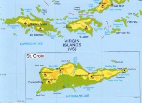
| location: Central America ; West Indies ; Caribbean ; Lesser Antilles |
| time zone: -4 UT |
| surface (land) area: 340 sq.km = 131 sq.mi //; - area incl. inland waters: sq.km = sq.mi |
| geographical position in extreme co-ordinates: North/South: 18° N / East/West: 65° W |
| borders (land): none |
| borders (coastline): Atlantic Ocean, Caribbean Sea |
| climate: subtropical Caribbean, tempered by trade winds, low humidity |
| Government |
| independent since: not yet |
| type of government: unincorporated territory of the USA (purchased from Denmark in 1917) |
| capital: Charlotte Amalie |
| administrative division: none; the US Census Bureau uses the 3 main islands as enumeration districts |
| Population |
| population according to the latest census (1990): 101,809 |
| total population according to the estimate of midyear 2000: 120,917 /-; 2001: 122,200 |
| population density: 356 per sq.km = 922 per sq.mi |
| population growth: 1,5% //; - doubling time: ca 50 years |
| birth rate: 18 per 1000 |
| death rate: 5 per 1000 |
| fertility rate: 2 children per female |
| maternal mortality: per 100,000 |
| infant mortality (1-4 years): 19 per 1000 |
| life expectancy: 73 years (male: 70; female: 76) |
| age breakdown: 0-14 years: 28% //; - 15-59 years: 63% //; - 60+ years: 9% |
| urbanisation: 37% //; - urbanisation growth: % |
| percentage of urban population in the greatest city: % |
| Ethnic composition, language, religion |
| ethnic groups: black (mainly of African descent) 80%; white 15% |
| languages: English (official); Spanish, Creole |
| religious affiliation: Baptist 42%; Roman Catholic 34% |
| Health |
| daily food intake: calories per capita |
| population with access to safe water: % |
| people per physician: 700 |
| people per hospital bed: |
| Education, literacy |
| school enrolment: primary education 6-11 years: 50% |
| school enrolment: secondary education: % |
| school enrolment: tertiary education 20-24 years: % |
| adult literacy: % (male: %; female: %) |
| Economy and infrastructure |
| Economy and trade |
| currency: US dollar |
| annual inflation rate: % |
| population below poverty line: % |
| Gross Domestic Product: USD per capita |
| GNI USD per capita //; - [ppp: ] |
| GDP growth: % |
| income: USD 15000 per capita |
| import: USD 3200 per capita //; - export: USD 3026 per capita |
| trade: USD 6000 per capita //; - or % of GDP |
| trade partners: US |
| human development index: //; - position of the country in the world no.: |
| female labour force: 43% |
| unemployment: 5% |
| tourism: 0,6 million |
| Economic activities in agriculture, fisheries, industry, mining, services, energy |
| land use: arable land: 21% //; - grass land: 26% //; - wooded area: 6% //; - arid land and desert: % |
| agriculture: labour force: 1% //; - part of agriculture in GDP: % |
| agricultural products: vegetables, horticulture, fruits & nuts (all of little importance) |
| livestock (1000s): cattle: 6,6 - 8 / goats: 4 / pigs: 1,4 - 3 / poultry: 3,5 - 35 / sheep: 3 |
| fish catch: metric tonnes |
| industry: labour force: 23% //; - part of industry in GDP: % |
| industrial products: tourism, notably cruise ships and airborne daytrippers; rum, textiles, pharmaceuticals, perfumes |
| mining products: sand & gravel (of no importance) |
| CO2 emission per capita: 99,0 |
| services: labour force: 76% //; - part of services in GDP: % |
| energy use (kg per capita): 33843 |
| electricity use (per capita): |
| annual water use (per capita): |
| Traffic, communication |
| road network: 856 km //; - of which paved: 100% //; - of which are motorways: 0 km |
| vehicles: 500 per 1000 |
| railways: 0 km //; - railways passenger/km: - |
| navigable inland waterways: 0 km |
| ownership telephone: 597 per 1000 |
| ownership radio receivers: 1029 per 1000 |
| ownership tv-sets: 600 per 1000 |
| newspaper circulation: 287 per 1000 |
| persons per post office: 10800 |
| personal computers: per 1000 |
| Some physical landmarks |
| mountains: Crown Mountain 474 m, Bordeaux Mt. 389, Mt. Eagle 355, Pater Peak 295, Nulliberg 264 |
| lowest point: sea level |
| lakes (natural): none, or unknown |
| lakes (artificial reservoirs): none, or unknown |
| lakes (deepest): unknown |
| rivers: not found in atlantes or on maps; possibly of no importance, or only some small ones for mountain drainage |
| canals: none, or unknown |
| waterfalls: none, or unknown |
| caves: longest system: none, or unknown / deepest: |
| islands: see the separate file of the administrative division |
| deserts: none |
| other natural features: |
| Additional remarks, especially on the statistical information |
| other important features: |
| apart from physical landmarks most of the above figures are changeable, in most cases they date from the 1990's |
| Spanish territory from 1553-1672; Danish colony from 1672-1917 |
| primary sources used for the general information: |
| BB CA EV PW WA WB WR, and some national statistical yearbooks |
| particulars concerning population data: |
 To the page containing the population growth statistics of the country
 To the page containing the historical population growth statistics of the islands
 To the page containing urban historical population statistics
 Back to the homepage of this website: POPULATION STATISTICS
Internet website:Latest modification of this page on 2004-03-14 by Jan Lahmeyer
© "populstat" site: Jan Lahmeyer