All countries of the world listed from A-Z:

or choose from the countries per continent below:


 |  |  |  |  |  |
 | SAINT LUCIAgeneral data of the country |
| General useful information |
| Note: some data are of constant value, while other are due to changes, fluctuations etc. |
| Nation and population |
| official name (short form): Saint Lucia |
| country code ISO: LC //; - FIPS: ST |
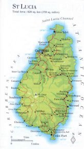
| location: Central America, West Indies, Caribbean, Lesser Antilles |
| time zone: -4 UT |
| surface (land) area: 617 sq.km = 238 sq.mi //; - area incl. inland waters: sq.km = sq.mi |
| geographical position in extreme co-ordinates: North/South: 14° N / East/West: 61° W |
| borders (land): none |
| borders (coastline): Caribbean Sea |
| climate: tropical Caribbean |
| Government |
| independent since: 1979-02-22 |
| type of government: federative republic within the United Kingdom |
| capital: Castries |
| administrative division: district (10) |
| Population |
| population according to the latest census (1991): 133,308, or: 135,685 |
| total population according to the estimate of midyear 2000: 156,260 /-; 2001: 158,178 |
| population density: 253 per sq.km = 656 per sq.mi |
| population growth: 2% //; - doubling time: 41 years |
| birth rate: 22 - 25 per 1000 |
| death rate: 5 - 6 per 1000 |
| fertility rate: 3 children per female |
| maternal mortality: per 100,000 |
| infant mortality (1-4 years): 18 per 1000 |
| life expectancy: 73 years (male: 69; female: 76) |
| age breakdown: 0-14 years: 36% //; - 15-59 years: 55% //; - 60+ years: 9% |
| urbanisation: 38 - 48% //; - urbanisation growth: % |
| percentage of urban population in the greatest city: % |
| Ethnic composition, language, religion |
| ethnic groups: black 90,5%; mixed 5,5%; East Indian 3,2%; white 0,8% |
| languages: English (official); French patois |
| religious affiliation: Roman Catholic 79%; Protestant 15,5% (Seventh-day Adventists, Pentecostal) |
| Health |
| daily food intake: calories per capita |
| population with access to safe water: 100% |
| people per physician: 2235 |
| people per hospital bed: |
| Education, literacy |
| school enrolment: primary education 6-11 years: 82% |
| school enrolment: secondary education: 7% |
| school enrolment: tertiary education 20-24 years: 1% |
| adult literacy: 80% (male: %; female: %) |
| Economy and infrastructure |
| Economy and trade |
| currency: Eastern Caribbean dollar = 100 cents |
| annual inflation rate: 3% |
| population below poverty line: % |
| Gross Domestic Product: USD 3450 per capita |
| GNI USD 4120 per capita //; - [ppp: 5400] |
| GDP growth: 1% |
| income: USD 2500 per capita |
| import: USD 300 per capita //; - export: USD 120 per capita |
| trade: USD 2267 per capita //; - or 61% of GDP |
| trade partners: GB US TT JP |
| human development index: 0,749 //; - position of the country in the world no.: ca 70 |
| female labour force: 40% |
| unemployment: 15,5% |
| tourism: 0,26 million |
| Economic activities in agriculture, fisheries, industry, mining, services, energy |
| land use: arable land: 30% //; - grass land: 5% //; - wooded area: 13% //; - arid land and desert: % |
| agriculture: labour force: 26% //; - part of agriculture in GDP: 16% |
| agricultural products: bananas, copra, breadfruit, mangoes, cocoa, pepper, plantains, pineapples, coconuts, vegetables, citrus, root crops |
| livestock (1000's): asses 1 / cattle: 12,4 / goats: 9,8 / horses 1 / pigs: 14,7 / poultry: 210 / sheep: 12,5 |
| fish catch: metric tonnes |
| industry: labour force: 9% //; - part of industry in GDP: 22% |
| industrial products: food & beverages, paper & cardboard products, garments, clothing |
| mining products: of no importance |
| CO2 emission per capita: 1,3 |
| services: labour force: 60% //; - part of services in GDP: 62% |
| energy use (kg per capita): 338 |
| electricity use (per capita): |
| annual water use (per capita): |
| Traffic, communication |
| road network: 970 km //; - of which paved: 56% //; - of which are motorways: 0 km |
| vehicles: 43 per 1000 |
| railways: 0 km //; - railways passenger/km: - |
| navigable inland waterways: 0 km |
| ownership telephone: 121 - 266 per 1000 |
| ownership radio receivers: 575 - 746 per 1000 |
| ownership tv-sets: 18 - 211 per 1000 |
| newspaper circulation: per 1000 |
| persons per post office: |
| personal computers: 141 per 1000 |
| Some physical landmarks |
| mountains: Mount Gimie 951 m, Gros Piton 798, Petit Piton 743, La Sorcière 677 |
| lowest point: sea level |
| lakes (natural): none, or unknown |
| lakes (artificial reservoirs): none, or unknown |
| lakes (deepest): unknown |
| rivers: a few small rivers only to drain the mountain slopes: like Cul de Sac, Roseau, Canelles |
| canals: none, or unknown |
| waterfalls: none, or unknown |
| caves: longest system: none, or unknown / deepest: |
| islands: see the separate file of the administrative division |
| deserts: none |
| other natural features: |
| Additional remarks, especially on the statistical information |
| other important features: |
| apart from physical landmarks most of the above figures are changeable, in most cases they date from the 1990's |
| primary sources used for the general information: |
| BB CA EV PW WA WB WR, and some national statistical yearbooks |
| particulars concerning population data: |
 To the page containing the population growth statistics of the country
 To the page containing the historical population growth statistics of the provinces
 To the page containing urban historical population statistics
 Back to the homepage of this website: POPULATION STATISTICS
Latest modification of this page on 2004-03-07 by Jan Lahmeyer
© "populstat" site: Jan Lahmeyer