All countries of the world listed from A-Z:

or choose from the countries per continent below:


 |  |  |  |  |  |
 | MONTSERRATgeneral data of the country |
| General useful information |
| Note: some data are of constant value, while other are due to changes, fluctuations etc. |
| Nation and population |
| official name (short form): Montserrat |
| country code ISO: MS //; - FIPS: MH |
| location: Central America, West Indies, Caribbean, Lesser Antilles |
| time zone: -4 UT |
| surface (land) area: 106 sq.km = 39.5 sq.mi |
| geographical position in extreme co-ordinates: North/South: 17° N / East/West: 62° W |
| borders (land): none |
| borders (coastline): Caribbean Sea |
| climate: tropical Caribbean |
| Government |
| independent since: not yet |
| type of government: dependent territory of the United Kingdom |
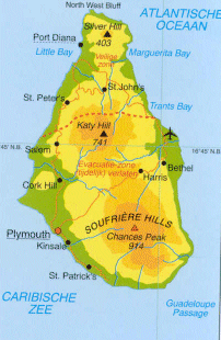
| capital: Plymouth (planned capital Port Diana) |
| administrative division: parish (3) |
| Population |
| population according to the latest census (1991): 10,639 |
| total population according to the estimate in 1995 13,000; it is supposed to be practically uninhabited since 1997-08 |
| population density was: 127 per sq.km = 329 per sq.mi |
| population growth: 0,6% //; - doubling time: not applicable any more |
| birth rate: 17 per 1000 |
| death rate: 10 per 1000 |
| fertility rate: 2 children per female |
| maternal mortality: per 100,000 |
| infant mortality (1-4 years): 11 per 1000 |
| life expectancy: years (male: ; female: ) |
| age breakdown: 0-14 years: % //; - 15-59 years: % //; - 60+ years: % |
| urbanisation: 12% //; - urbanisation growth: % |
| percentage of urban population in the greatest city: % |
| Ethnic composition, language, religion |
| ethnic groups: black, European |
| languages: English, Creole |
| religious affiliation: Anglican 25%; Methodist 20%; Pentecostal 15%; Roman Catholic 10%; Adventist 10% |
| Health |
| daily food intake: calories per capita |
| population with access to safe water: % |
| people per physician: |
| people per hospital bed: |
| Education, literacy |
| school enrolment: primary education 6-11 years: % |
| school enrolment: secondary education: % |
| school enrolment: tertiary education 20-24 years: % |
| adult literacy: % (male: %; female: %) |
| Economy and infrastructure |
| Economy and trade |
| currency: East Caribbean dollar = 100 cents |
| annual inflation rate: % |
| population below poverty line: % |
| Gross Domestic Product: USD per capita |
| GNI USD per capita //; - [ppp: ] |
| GDP growth: % |
| income: USD 4000 per capita |
| import: USD per capita //; - export: USD per capita |
| trade: USD 2000 per capita //; - or % of GDP |
| trade partners: |
| human development index: //; - position of the country in the world no.: |
| female labour force: % |
| unemployment: % |
| tourism: 0,001 million |
| Economic activities in agriculture, fisheries, industry, mining, services, energy |
| land use: arable land: 20% //; - grass land: 10% //; - wooded area: 40% //; - arid land and desert: % |
| agriculture: labour force: 4% //; - part of agriculture in GDP: % |
| agricultural products: hot peppers |
| livestock (1000s): cattle: 4 / goats: 4 / pigs: 0,4 / poultry: 60 / sheep: 4 |
| fish catch: 50 metric tonnes |
| industry: labour force: 6% //; - part of industry in GDP: % |
| industrial products: none, or unknown |
| mining products: none, or unknown |
| CO2 emission per capita: |
| services: labour force: 90% //; - part of services in GDP: % |
| energy use (kg per capita): |
| electricity use (per capita): |
| annual water use (per capita): |
| Traffic, communication |
| road network: 20, or 205 km //; - of which paved: % //; - of which are motorways: 0 km |
| vehicles: per 1000 |
| railways: 0 km //; - railways passenger/km: - |
| navigable inland waterways: 0 km |
| ownership telephone: 345 per 1000 |
| ownership radio receivers: per 1000 |
| ownership tv-sets: per 1000 |
| newspaper circulation: per 1000 |
| persons per post office: |
| personal computers: per 1000 |
| Some physical landmarks |
| mountains: Chances Peak (Soufrière Hills) 914 m, Katy Hill 741, Silver Hill 403 |
| lowest point: sea level |
| lakes (natural): none, or unknown |
| lakes (artificial reservoirs): none, or unknown |
| lakes (deepest): unknown |
| rivers: a few small ones to drain the mountain slopes |
| canals: none, or unknown |
| waterfalls: none, or unknown |
| caves: longest system: none, or unknown / deepest: |
| islands: none |
| deserts: none |
| other natural features: |
| Additional remarks, especially on the statistical information |
| other important features: |
| apart from physical landmarks most of the above figures are changeable, in most cases they date from the 1990's |
| due to the volcanic activity of the Soufrière volcano since 1995 the island was practically totally evacuated in 1997 |
| so most of the data here above are more or less only of historical interest |
| primary sources used for the general information: |
| BB CA EV PW WA WB WR, and some national statistical yearbooks |
| particulars concerning population data: |
| estimated population in 2001: 5,000 (according to source CA), or: 7,574 (source WA) |
 To the page containing the population growth statistics of the country
 To the page containing the historical population growth statistics of the provinces
 To the page containing urban historical population statistics
 Back to the homepage of this website: POPULATION STATISTICS
Latest modification of this page on 2004-02-27 by Jan Lahmeyer
© "populstat" site: Jan Lahmeyer