All countries of the world listed from A-Z:

or choose from the countries per continent below:


 |  |  |  |  |  |
 | MARTINIQUEgeneral data of the country |
| General useful information |
| Note: some data are of constant value, while other are due to changes, fluctuations etc. |
| Nation and population |
| official name (short form): Martinique |
| country code ISO: MQ //; - FIPS: MB |
| location: Central America, West Indies, Caribbean, Smaller Antilles |
| time zone: -4 UT |
| surface (land) area: 1100 sq.km = 425 sq.mi //; - area incl. inland waters: sq.km = sq.mi |
| geographical position in extreme co-ordinates: North/South: 15° N / East/West: 61° W |
| borders (land): none |
| borders (coastline): Atlantic Ocean, Caribbean Sea |
| climate: tropical Caribbean |
| Government |
| independent since: not yet |
| type of government: overseas department of France since 1946-03 |
| capital: Fort-de-France |
| administrative division: commune (34) |
| Population |
| population according to the latest census (1999): 383,900 |
| total population according to the estimate of midyear 2000: 414,516 / -; 2001: 387,000 |
| population density: 350 per sq.km = 906 per sq.mi |
| population growth: 0,9% //; - doubling time: 77 years |
| birth rate: 15 - 18 per 1000 |
| death rate: 7 per 1000 |
| fertility rate: 2 children per female |
| maternal mortality: per 100,000 |
| infant mortality (1-4 years): 4 per 1000 |
| life expectancy: 79 years (male: 76; female: 82) |
| age breakdown: 0-14 years: 24% //; - 15-59 years: 62% //; - 60+ years: 14% |
| urbanisation: 75% //; - urbanisation growth: % |
| percentage of urban population in the greatest city: % |
| Ethnic composition, language, religion |
| ethnic groups: of African descent, mixed, white. Mulatto 93,7%; French 2,6%; other 3,7% |
| languages: French (official); Creole patois |
| religious affiliation: Roman Catholic 78%; Protestant 8% |
| Health |
| daily food intake: calories per capita |
| population with access to safe water: % |
| people per physician: |
| people per hospital bed: |
| Education, literacy |
| school enrolment: primary education 6-11 years: 82% |
| school enrolment: secondary education: 20% |
| school enrolment: tertiary education 20-24 years: 7% |
| adult literacy: 93% (male: %; female: %) |
| Economy and infrastructure |
| Economy and trade |
| currency: Euro = 100 cents (until 2002: French franc = 100 centimes) |
| annual inflation rate: % |
| population below poverty line: % |
| Gross Domestic Product: USD 1510 per capita |
| GNI USD per capita //; - [ppp: ] |
| GDP growth: 4% |
| income: USD 4000 per capita |
| import: USD 1970 per capita //; - export: USD 242 per capita |
| trade: USD 5308 per capita //; - or % of GDP |
| trade partners: FR |
| human development index: //; - position of the country in the world no.: |
| female labour force: 48% |
| unemployment: % |
| tourism: 0,9 million |
| Economic activities in agriculture, fisheries, industry, mining, services, energy |
| land use: arable land: 19% //; - grass land: 18% //; - wooded area: 44% //; - arid land and desert: % |
| agriculture: labour force: 7% //; - part of agriculture in GDP: 6% |
| agricultural products: bananas, sugar cane, pineapples, rum |
| livestock (1000s): cattle: 25-30 / goats: 17 / pigs: 33-35 / poultry: 250 / sheep: 34-42 |
| fish catch: 5000 metric tonnes |
| industry: labour force: 5% //; - part of industry in GDP: 13% |
| industrial products: cement, food processing, oil refining |
| mining products: pumice |
| CO2 emission per capita: |
| services: labour force: 88% //; - part of services in GDP: 81% |
| energy use (kg per capita): 963 |
| electricity use (per capita): |
| annual water use (per capita): 199 |
| Traffic, communication |
| road network: 2069, or 2176 km //; - of which paved: 75% //; - of which are motorways: 0 km |
| vehicles: 370 per 1000 |
| railways: 0 km //; - railways passenger/km: - |
| navigable inland waterways: 0 km |
| ownership telephone: 381 - 443 per 1000 |
| ownership radio receivers: 187 - 213 per 1000 |
| ownership tv-sets: 137 - 171 per 1000 |
| newspaper circulation: 84 per 1000 |
| persons per post office: |
| personal computers: 93 per 1000 |
| Some physical landmarks |
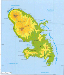
| mountains: Mont Pelée 1397 m, + two other [on available maps nameless] peaks of 1196 and 884 m |
| lowest point: sea level |
| lakes (natural): none, or unknown |
| lakes (artificial reservoirs): none, or unknown |
| lakes (deepest): unknown |
| rivers: a few short rivers to drain the mountain slopes |
| canals: none, or unknown |
| waterfalls: none, or unknown |
| caves: longest system: none, or unknown / deepest: |
| islands: none, or unknown |
| deserts: none |
| other natural features: |
| Additional remarks, especially on the statistical information |
| other important features: |
| apart from physical landmarks most of the above figures are changeable, in most cases they date from the 1990's |
| French possession since 1635 |
| primary sources used for the general information: |
| BB CA EV PW WA WB WR, and some national statistical yearbooks |
| particulars concerning population data: |
 To the page containing the population growth statistics of the country
 To the page containing the historical population growth statistics of the provinces
 To the page containing urban historical population statistics
 Back to the homepage of this website: POPULATION STATISTICS
Internet website: For more figures of FranceLatest modification of this page on 2004-02-25 by Jan Lahmeyer
© "populstat" site: Jan Lahmeyer