All countries of the world listed from A-Z:

or choose from the countries per continent below:


 |  |  |  |  |  |
 | DOMINICAgeneral data of the country |
| General useful information |
| Note: some data are of constant value, while other are due to changes, fluctuations etc. |
| Nation and population |
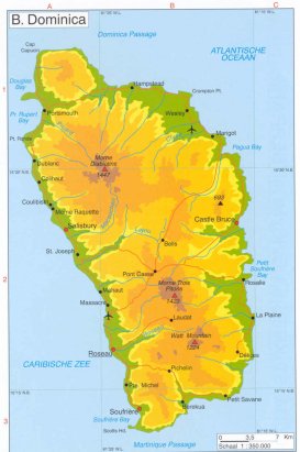
| official name (short form): Dominica |
| country code ISO: DM [DMA] //; - FIPS: DO |
| location: Central America, West-Indies, Caribbean, Lesser Antilles |
| time zone: -4 UT |
| surface (land) area: 749,8 sq.km = 289,5 sq.mi //; - area incl. inland waters: 751 sq.km = 290 sq.mi |
| geographical position in extreme co-ordinates: North/South: 15° N / East/West: 61° W |
| borders (land): none |
| borders (coastline): Caribbean Sea, Atlantic Ocean |
| climate: Caribbean (sub)tropical in trade winds area |
| Government |
| independent since: 1978-11-03 |
| type of government: republic |
| capital: Roseau |
| administrative division: parich (10) |
| Population |
| population according to the last two censuses: 1991: 71,183 /-; 2001: 71,727 |
| total population according to the estimate of midyear 2000: 71,540; or: 73,000 /-; 2001: 71,000 /-; 2002: 72,000 |
| population density: 95 per sq.km = 245 per sq.mi |
| population growth: 0,1% //; - doubling time: 53 years [recently the pop. tends to be stable] |
| birth rate: 18 - 21 per 1000 |
| death rate: 5 - 7 per 1000 |
| fertility rate: 3 children per female |
| maternal mortality: per 100,000 |
| infant mortality (in the first year of life): 14 - 17 per 1000 |
| infant mortality (from 1st - 4th year of life): 9 - 13 per 1000 |
| life expectancy: 76-78 years (male: 73-75; female: 79-81) |
| age breakdown: 0-14 years: 23% [PG: 31%] //; - 15-59 years: 65% [PG: 57%] //; - 60+ years: 12% |
| urbanisation: 41% //; - urbanisation growth: % |
| percentage of urban population in the greatest city: % |
| Ethnic composition, language, religion |
| ethnic groups: predominantly of African descent: Black 89%; Mestizo 7%; Amerindian 1,5%; white minority |
| languages: English, French patois |
| religious affiliation: Roman Catholic 70% [PG: 75%] ; Protestant 17% [PG: 15%]; other 13% |
| Health |
| daily food intake: calories per capita |
| population with access to safe water: 97% |
| people per physician: 2000 - 2041 |
| people per hospital bed: |
| Education, literacy |
| school enrolment: primary education 6-11 years: 96% |
| school enrolment: secondary education: 13% |
| school enrolment: tertiary education 20-24 years: 3% |
| adult literacy: 97% (male: %; female: %) |
| Economy and infrastructure |
| Economy and trade |
| currency: East Caribbean dollar (EC$) = 100 cents |
| annual inflation rate: 3% |
| population below poverty line: % |
| Gross Domestic Product: USD 2990 per capita |
| GNI USD 3000 - 3260 per capita //; - [ppp: 4960] |
| GDP growth: 3 - 4% |
| income: USD 950 -2990 per capita |
| import: USD 110 per capita //; - export: USD 54 per capita |
| trade: USD 2163 per capita //; - or 74% of GDP |
| trade partners: GB JM US TT IT LC CA AG GY CN KR |
| human development index: 0,800 //; - position of the country in the world no.: ca 47 ? |
| female labour force: 34% |
| unemployment: 20 - 23% |
| tourism: 0,07 million |
| Economic activities in agriculture, fisheries, industry, mining, services, energy |
| land use: arable land: 23% //; - grass land: 3% //; - wooded area: 41% //; - arid land and desert: % |
| agriculture: labour force: 25% [PG: 31% ; FW 1997: 24%] //; - part of agriculture in GDP: 27% [FW 2002: 19%] |
| agricultural products: bananas, coconuts, root crops, grapefruit, mangoes, citrus, plantains, oranges, cacao, bay oil |
| livestock (1000s): asses: / cattle: 13 / goats: 10 / horses: / pigs: 5 / poultry: 190 / sheep: 8 |
| fish catch: 1157 metric tonnes |
| industry: labour force: 12% [PG: 13% ; FW 1997: 18%] //; - part of industry in GDP: 16% [FW 2002: 21%] |
| industrial products: soap, copra, crude coconut oil, spring water |
| mining products: pumice, limestone, sand and gravel [all primarily quarried for local consumption] |
| CO2 emission per capita: |
| services: labour force: 63% [PG: 56% ; FW 1997: 54%] //; - part of services in GDP: 57% [FW 2002: 60%] |
| energy use (kg per capita): 290 |
| electricity use (per capita): |
| annual water use (per capita): |
| Traffic, communication |
| road network: 765 km //; - of which paved: 50% [390] //; - of which are motorways: 0 km |
| vehicles: 84 - 90 per 1000 // international license plate: WD |
| railways: 0 km //; - railways passenger/km: - |
| navigable inland waterways: 0 km |
| ownership telephone: 240 - 299 per 1000 // international dialling code: +1767 |
| ownership radio receivers: 875 per 1000 |
| ownership tv-sets: 141 - 175 per 1000 |
| newspaper circulation: per 1000 |
| persons per post office: 566 |
| personal computers: 71 per 1000 |
| Some physical landmarks |
| mountains: Morne Diablotins 1447 m, Morne Trois Pitons 1423 [1380], Watt Mountain 1224 [1330] |
| lowest point: sea level |
| lakes (natural): none |
| lakes (artificial reservoirs): unknown |
| lakes (deepest): unknown |
| rivers: Layou, Macoucheri, Picard, Roseau |
| canals: none |
| waterfalls: unknown |
| caves: longest system: unknown / deepest: |
| islands: none |
| deserts: none |
| other natural features: unknown |
| Additional remarks, especially on the statistical information |
| other important features: |
| apart from physical landmarks most of the above figures are changeable, in most cases they date from the 1990's |
| primary sources used for the general information: |
| BB CA DK EV FW PW WA WB WR, and some - local national or international - statistical yearbooks |
| particulars concerning population data: |
 To the page containing the population growth statistics of the country
 To the page containing the historical population growth statistics of the provinces
 To the page containing urban historical population statistics
 Back to the homepage of this website: POPULATION STATISTICS
Latest modification of this page on 2005-01-02 by Jan Lahmeyer
© "Populstat" website: Jan Lahmeyer