All countries of the world listed from A-Z:

or choose from the countries per continent below:


 |  |  |  |  |  |
 | ZAMBIAgeneral data of the country |
| General useful information |
| Note: some data are of constant value, while other are due to changes, fluctuations etc. |
| Nation and population |
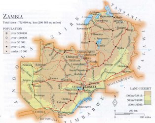
| official name (short form): Zambia |
| country code ISO: ZM //; - FIPS: ZA |
| location: Central Southern Africa |
| time zone: +2 UT |
| surface (land) area: 752614 sq.km = 290586= sq.mi //; - area incl. inland waters: sq.km = sq.mi |
| geographical position in extreme co-ordinates: North: 8° S / South: 18° S / East: 34° E / West: 22° E |
| borders (land): Congo Kinshasa, Tanzania, Malawi, Zimbabwe, Namibia, Angola |
| borders (coastline): none |
| climate: tropical, humidity tempered by altitude |
| Government |
| independent since: 1964-10-24 |
| type of government: republic |
| capital: Lusaka |
| administrative division: province (9) |
| Population |
| population according to the latest census (1990): 7818,447 |
| total population according to the estimate of midyear 2000: 9582,418; or: 10089,000 /-; 2001: 9343,000; or: 9770,199 |
| population density: 13 per sq.km = 33 per sq.mi |
| population growth: 3% //; - doubling time: 24 years |
| birth rate: 41 - 45 per 1000 |
| death rate: 15 - 22 per 1000 |
| fertility rate: 6 - 7 children per female |
| maternal mortality: 150 per 100,000 |
| infant mortality (1-4 years): 104 per 1000 |
| life expectancy: 38 - 45 years (male: 37 - 45; female: 38 - 46) |
| age breakdown: 0-14 years: 49% //; - 15-59 years: 47% //; - 60+ years: 4% |
| urbanisation: 40% //; - urbanisation growth: 5% |
| percentage of urban population in the greatest city: 35% |
| Ethnic composition, language, religion |
| ethnic groups: Bemba 39%; Maravi (Nyanja) 20%; Tonga 15%; North-Western peoples 10%; Barotze 8%; European 1% |
| languages: English (official); Bemba, Tonga, Nyanja, Lozi, Lunda, Luvale, Kaonde |
| religious affiliation: traditional beliefs 27%; Protestant 23%; Roman Catholic 17%; Hindu & Muslim 24%; African Christian 8% |
| Health |
| daily food intake: 1950 calories per capita |
| population with access to safe water: 43 - 64% |
| people per physician: 6959 |
| people per hospital bed: |
| Education, literacy |
| school enrolment: primary education 6-11 years: 95% |
| school enrolment: secondary education: 17% |
| school enrolment: tertiary education 20-24 years: 2% |
| adult literacy: 78% (male: 86%; female: 71%) |
| Economy and infrastructure |
| Economy and trade |
| currency: Zambian kwacha = 100 ngwee |
| annual inflation rate: 51% |
| population below poverty line: 86% |
| Gross Domestic Product: USD 350 - 960 per capita |
| GNI USD 300 per capita //; - [ppp: 750] |
| GDP growth: -2% |
| income: USD 420 per capita |
| import: USD 1238 per capita //; - export: USD 1049 per capita |
| trade: USD 265 per capita //; - or 54% of GDP |
| trade partners: ZA GB US JP CN |
| human development index: 0,427 //; - position of the country in the world no.: 143 |
| female labour force: 45% |
| unemployment: % |
| tourism: 0,6 million |
| Economic activities in agriculture, fisheries, industry, mining, services, energy |
| land use: arable land: 7% //; - grass land: 40% //; - wooded area: 39% //; - arid land and desert: % |
| agriculture: labour force: 38% //; - part of agriculture in GDP: 16% |
| agricultural products: sugarcane, corn/maize, cassava, fruits & vegetables, sweet potatoes, millet/sorghum |
| livestock (million): cattle: 2,4 / goats: 1,2 / pigs: 0,3 / poultry: 29 / sheep: 0,14 |
| fish catch: 67300 - 70700 metric tonnes |
| industry: labour force: 8% //; - part of industry in GDP: 47% |
| industrial products: copper, cement, sugar, flour, zinc, lead, cigarettes, construction, foodstuffs, chemicals |
| mining products: copper, cobalt, coal, zinc, lead, gold, emeralds, amethyst, silver, uranium |
| CO2 emission per capita: 0,2 |
| services: labour force: 55% //; - part of services in GDP: 37% |
| energy use (kg per capita): 626 |
| electricity use (per capita): 540 |
| annual water use (per capita): 186 |
| Traffic, communication |
| road network: 38898 km //; - of which paved: 18% //; - of which are motorways: 0 km |
| vehicles: 9 per 1000 |
| railways: 1273, or 2164 km //; - railways passenger/km: 267 |
| navigable inland waterways: 2250 km |
| ownership telephone: 8 - 9 per 1000 |
| ownership radio receivers: 99 - 139 per 1000 |
| ownership tv-sets: 32 - 64 per 1000 |
| newspaper circulation: per 1000 |
| persons per post office: 44200 |
| personal computers: 7 per 1000 |
| Some physical landmarks |
| mountains: Sunzu 2067 m, Luangwa 1848, Chimbwingombi 1788, nameless 1769, nameless 1585, nameless 1553, Vimbe 1544 |
| lowest point: in the Southeast corner where the Zambeze river leaves the country |
| lakes (natural): Lake Mweru, Lake Tanganyika, Lake Bangweulu |
| lakes (artificial reservoirs): Lake Kariba |
| lakes (deepest): Lake Tanganyika |
| rivers: Zambezi, Luangwa, Kafue |
| canals: none, or unknown |
| waterfalls: Victoria 104,5 m |
| caves: longest system: / deepest: |
| islands: none |
| deserts: none |
| other natural features: |
| Additional remarks, especially on the statistical information |
| other important features: |
| apart from physical landmarks most of the above figures are changeable, in most cases they date from the 1990's |
| primary sources used for the general information: |
| BB CA EV PW WA WB WR, and some national statistical yearbooks |
| particulars concerning population data: |
 To the page containing the population growth statistics of the country
 To the page containing the historical population growth statistics of the provinces
 To the page containing urban historical population statistics
 Back to the homepage of this website: POPULATION STATISTICS
Internet website:Latest modification of this page on 2004-03-15 by Jan Lahmeyer
© "populstat" site: Jan Lahmeyer