All countries of the world listed from A-Z:

or choose from the countries per continent below:


 |  |  |  |  |  |
 | SENEGALgeneral data of the country |
| General useful information |
| Note: some data are of constant value, while other are due to changes, fluctuations etc. |
| Nation and population |
| official name (short form): Sénégal |
| country code ISO: SN //; - FIPS: SG |
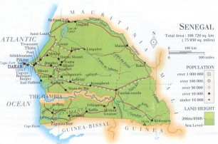
| location: West Africa |
| time zone: +0 UT |
| surface (land) area: 196720 sq.km = 75950 sq.mi //; - area incl. inland waters: sq.km = sq.mi |
| geographical position in extreme co-ordinates: North: 17° N / South: 12° N / East: 11° W / West: 18° W |
| borders (land): Mauritania, Mali, Guinea, Guinea-Bissau, Gambia |
| borders (coastline): Atlantic Ocean |
| climate: tropical, somewhat cooler in the coastal regions |
| Government |
| independent since: 1960-08-20 |
| type of government: republic |
| capital: Dakar |
| administrative division: région (10) |
| Population |
| population according to the latest census (1988): 6928,405 |
| total population according to the estimate of midyear 2000: 9987,494; or: 9530,000 /-; 2001: 9802,778; or:10284,929 |
| population density: 51 per sq.km = 132 per sq.mi |
| population growth: 3% //; - doubling time: 23 years |
| birth rate: 37 - 43 per 1000 |
| death rate: 8 - 12 per 1000 |
| fertility rate: 6 children per female |
| maternal mortality: 600 per 100,000 |
| infant mortality (1-4 years): 74 per 1000 |
| life expectancy: 52 - 62 years (male: 56 - 61; female: 58 - 64) |
| age breakdown: 0-14 years: 45% //; - 15-59 years: 50% //; - 60+ years: 5% |
| urbanisation: 47% //; - urbanisation growth: 3% |
| percentage of urban population in the greatest city: 65% |
| Ethnic composition, language, religion |
| ethnic groups: Wolof 43%; Serer 15%; Fulani (Peul) 14%; Tukulor 9%; Diola 5%; Mandingo 4%; other 10% |
| languages: French (official) and African Sudanese dialects like Wolof, Pulaar, Diola, Mandingo |
| religious affiliation: Sunnî Muslim 92%; traditional beliefs 6%; Christian (predominantly Roman Catholic) 2% |
| Health |
| daily food intake: 2277 calories per capita |
| population with access to safe water: 78% |
| people per physician: 14825 |
| people per hospital bed: |
| Education, literacy |
| school enrolment: primary education 6-11 years: 42% |
| school enrolment: secondary education: 10% |
| school enrolment: tertiary education 20-24 years: 2% |
| adult literacy: 33 - 36% (male: 43%; female: 23%) |
| Economy and infrastructure |
| Economy and trade |
| currency: CFA franc = 100 centimes |
| annual inflation rate: 4,6% |
| population below poverty line: 33% |
| Gross Domestic Product: USD 610 - 1730 per capita |
| GNI USD 490 per capita //; - [ppp: 1480] |
| GDP growth: 1% |
| income: USD 720 per capita |
| import: USD 1139 per capita //; - export: USD 605 per capita |
| trade: USD 235 per capita //; - or 57% of GDP |
| trade partners: FR NI IT US IN ML |
| human development index: 0,423 //; - position of the country in the world no.: 145 |
| female labour force: 43% |
| unemployment: % |
| tourism: 0,4 million |
| Economic activities in agriculture, fisheries, industry, mining, services, energy |
| land use: arable land: 12% //; - grass land: 16 - 30% //; - wooded area: 40 - 55% //; - arid land and desert: 19% |
| agriculture: labour force: 81% //; - part of agriculture in GDP: 20% |
| agricultural products: sugarcane, groundnuts, millet, paddy rice, sorghum, maize, cassava, cotton |
| livestock (million): cattle: 3,1 / goats: 3,9 / horses: 0,5 / pigs: 0,3 / poultry: 45 / sheep: 4,5 |
| fish catch: 418100 - 507000 metric tonnes |
| industry: labour force: 6% //; - part of industry in GDP: 19% |
| industrial products: cement, sugar, wheat flour, canned fish, light chemicals (fertilizers, soap) |
| mining products: calsium phosphate, salt, aluminium phosphate, natural gas, marble, iron, copper |
| CO2 emission per capita: 0,4 |
| services: labour force: 13% //; - part of services in GDP: 62% |
| energy use (kg per capita): 318 |
| electricity use (per capita): 114 |
| annual water use (per capita): 202 |
| Traffic, communication |
| road network: 14580 km //; - of which paved: 29% //; - of which are motorways: 0 km |
| vehicles: 9 per 1000 |
| railways: 897, or: 1186 km //; - railways passenger/km: 206 |
| navigable inland waterways: 897 km |
| ownership telephone: 10 - 18 per 1000 |
| ownership radio receivers: 93 - 142 per 1000 |
| ownership tv-sets: 7 - 41 per 1000 |
| newspaper circulation: 6 per 1000 |
| persons per post office: 61100 |
| personal computers: 17 per 1000 |
| Some physical landmarks |
| mountains: on the border with Guinea a peak of 581 m, another peak of 419 m nw of Kédougou (no names found in atlantes or on maps) |
| lowest point: sea level |
| lakes (natural): Lac de Guier |
| lakes (artificial reservoirs): none, or unknown |
| lakes (deepest): unknown |
| rivers: Gambia, Senegal, Saloum, Casamance |
| canals: none, or unknown |
| waterfalls: none, or unknown |
| caves: longest system: none, or unknown / deepest: |
| islands: Île de Gorée |
| deserts: none |
| other natural features: |
| Additional remarks, especially on the statistical information |
| other important features: |
| apart from physical landmarks most of the above figures are changeable, in most cases they date from the 1990's |
| primary sources used for the general information: |
| BB CA EV PW WA WB WR, and some national statistical yearbooks |
| particulars concerning population data: |
 To the page containing the population growth statistics of the country
 To the page containing the historical population growth statistics of the provinces
 To the page containing urban historical population statistics
 Back to the homepage of this website: POPULATION STATISTICS
Internet website:Latest modification of this page on 2004-03-04 by Jan Lahmeyer
© "populstat" site: Jan Lahmeyer