All countries of the world listed from A-Z:

or choose from the countries per continent below:


 |  |  |  |  |  |
 | MOZAMBIQUEgeneral data of the country |
| General useful information |
| Note: some data are of constant value, while other are due to changes, fluctuations etc. |
| Nation and population |
| official name (short form): Moçambique |
| country code ISO: MZ //; - FIPS: MZ |
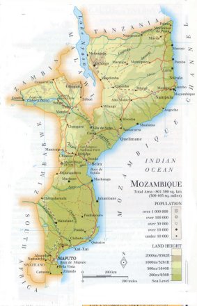
| location: Southeast Africa |
| time zone: +2 UT |
| surface (land) area: 812379 sq.km = 313661 sq.mi //; - area incl. inland waters: sq.km = sq.mi |
| geographical position in extreme co-ordinates: North: 10° S / South: 27° S / East: 41° E / West: 30° E |
| borders (land): Tanzania, Malawi, Zambia, Zimbabwe, South Africa, Swaziland |
| borders (coastline): Indian Ocean |
| climate: tropical |
| Government |
| independent since: 1975-06-25 |
| type of government: republic |
| capital: Maputo |
| administrative division: província (10) + city (1) |
| Population |
| population according to the last two censuses (1980): 11673,725 /-; (1997): 15278,334 |
| total population according to the estimate of midyear 2000: 17242,200; or: 17691,000; or: 19104,696 /-; 2001: 17587,000 |
| population density: 22 per sq.km = 57 per sq.mi |
| population growth: 2,5% //; - doubling time: 26 years |
| birth rate: 37 - 45 per 1000 |
| death rate: 18 - 24 per 1000 |
| fertility rate: 7 children per female |
| maternal mortality: 479 per 100,000 |
| infant mortality (1-4 years): 127 per 1000 |
| life expectancy: 42 years (male: 43; female: 41) |
| age breakdown: 0-14 years: 44% //; - 15-59 years: 51% //; - 60+ years: 5% |
| urbanisation: 40% //; - urbanisation growth: 7% |
| percentage of urban population in the greatest city: 83% |
| Ethnic composition, language, religion |
| ethnic groups: Makua 47%; Tsonga 23%; Malawi 12%; Shona 11%; Yao 4%; Swahili 1%; Makonde 0,5%; European 0,2% |
| languages: Portuguese (official); Bantu |
| religious affiliation: indigenous traditional beliefs 47%; Muslim 28%; Roman Catholic 12%; Protestant 9% |
| Health |
| daily food intake: 1911 calories per capita |
| population with access to safe water: 32 - 60% |
| people per physician: 140000 |
| people per hospital bed: |
| Education, literacy |
| school enrolment: primary education 6-11 years: 68% |
| school enrolment: secondary education: 5% |
| school enrolment: tertiary education 20-24 years: 0,2% |
| adult literacy: 43% (male: 57%; female: 31%) |
| Economy and infrastructure |
| Economy and trade |
| currency: Metcial (plural: Meticais) = 100 centavos |
| annual inflation rate: 33% |
| population below poverty line: 48% |
| Gross Domestic Product: USD 760 per capita |
| GNI USD 210 per capita //; - [ppp: 800] |
| GDP growth: 4% |
| income: USD 70 per capita |
| import: USD 544 per capita //; - export: USD 164 per capita |
| trade: USD 66 per capita //; - or 36% of GDP |
| trade partners: CIS-countries ZA FR PT US JP DE ES |
| human development index: 0,323 //; - position of the country in the world no.: 157 |
| female labour force: 48% |
| unemployment: % |
| tourism: 0 million |
| Economic activities in agriculture, fisheries, industry, mining, services, energy |
| land use: arable land: 4% //; - grass land: 56% //; - wooded area: 22% //; - arid land and desert: % |
| agriculture: labour force: 85% //; - part of agriculture in GDP: 37% |
| agricultural products: cassava, maize (corn), coconuts, sugarcane, sorghum, cashews, cotton, groundnuts, bananas |
| livestock (1000s): cattle: 1320 / goats: 392 / pigs: 180 / poultry: 23000-28000 / sheep: 122 |
| fish catch: 39579 metric tonnes / mainly shrimps |
| industry: labour force: 7% //; - part of industry in GDP: 46% |
| industrial products: food processing, textiles, chemicals |
| mining products: coal, iron, tantalite, bauxite, titanium, fluorspar, zirconium |
| CO2 emission per capita: 0,1 |
| services: labour force: 8% //; - part of services in GDP: 17% |
| energy use (kg per capita): 404 |
| electricity use (per capita): 53 |
| annual water use (per capita): 53 |
| Traffic, communication |
| road network: 26095, or 19810, or 30400 km //; - of which paved: 18% //; - of which are motorways: 0 km |
| vehicles: 3 per 1000 |
| railways: 3131 km //; - railways passenger/km: 312 |
| navigable inland waterways: 3750 km |
| ownership telephone: 3 - 4 per 1000 |
| ownership radio receivers: 36 - 40 per 1000 |
| ownership tv-sets: 3 - 4 per 1000 |
| newspaper circulation: 5 per 1000 |
| persons per post office: 40400 |
| personal computers: 3 per 1000 |
| Some physical landmarks |
| mountains: Monte Binga 2436 m, Serra Namúli 2419, Serra Jéci 1836 |
| lowest point: sea level |
| lakes (natural): Lago Malawi (Nyasa) |
| lakes (artificial reservoirs): Lago de Cahora Bassa |
| lakes (deepest): Lago Malawi (Nyasa) |
| rivers: Limpopo, Zambezi, Rovuma, Save, Púngoè, Lurio, Messalo |
| canals: none, or unknown |
| waterfalls: none, or unknown |
| caves: longest system: / deepest: |
| islands: several, of which Ilha da Bazaruto is the largest one |
| deserts: none |
| other natural features: |
| Additional remarks, especially on the statistical information |
| other important features: |
| apart from physical landmarks most of the above figures are changeable, in most cases they date from the 1990's |
| primary sources used for the general information: |
| BB CA EV PW WA WB WR, and some national statistical yearbooks |
| particulars concerning population data: |
 To the page containing the population growth statistics of the country
 To the page containing the historical population growth statistics of the provinces
 To the page containing urban historical population statistics
 Back to the homepage of this website: POPULATION STATISTICS
Internet website:Latest modification of this page on 2004-02-27 by Jan Lahmeyer
© "populstat" site: Jan Lahmeyer