All countries of the world listed from A-Z:

or choose from the countries per continent below:


 |  |  |  |  |  |
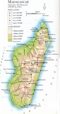 | MADAGASCAR [Malegasi, Madagaskar] |
| General useful information |
| Note: some data are of constant value, while other are due to changes, fluctuations etc. |
| Nation and population |
| official name (short form): Madagascar |
| country code ISO: MG //; - FIPS: MA |
| location: Southeast Africa |
| time zone: +3 UT |
| surface (land) area: 587041 sq.km = 226658 sq.mi //; - area incl. inland waters: sq.km = sq.mi |
| geographical position in extreme co-ordinates: North: 12° S / South: 26° / East: 50° E / West: 43° E |
| borders (land): none |
| borders (coastline): Indian Ocean |
| climate: tropical, with variations according to altitude |
| Government |
| independent since: 1960-06-26 |
| type of government: republic |
| capital: Tananarivo (Antananarivo) |
| administrative division: province [faritany] (6) |
| Population |
| population according to the latest census (1993): 12092,157 |
| total population according to the estimate of midyear 2000: 15506,472; or: 15523,000 / -; 2001: 16437,000 |
| population density: 26 per sq.km = 68 per sq.mi |
| population growth: 3,2% //; - doubling time: 22 years |
| birth rate: 44 per 1000 |
| death rate: 12 per 1000 |
| fertility rate: 6 children per female |
| maternal mortality: 240 per 100,000 |
| infant mortality (1-4 years): 110 per 1000 |
| life expectancy: 55 years (male: 53; female: 58) |
| age breakdown: 0-14 years: 45% //; - 15-59 years: 50% //; - 60+ years: 5% |
| urbanisation: 30% //; - urbanisation growth: 5% |
| percentage of urban population in the greatest city: 36% |
| Ethnic composition, language, religion |
| ethnic groups: Merina 26%; Betsimisaraka 15%; Betsileo 12%; Tsimihety 7%; Sakalava 6%; Antaisaka 5%; Antandroy 5% |
| languages: Malagasy, French (both official); English |
| religious affiliation: traditional beliefs 52%; Roman Catholic 21%; Protestant 20%; Muslim 7% |
| Health |
| daily food intake: 2001 calories per capita |
| population with access to safe water: 29% |
| people per physician: 8600 |
| people per hospital bed: |
| Education, literacy |
| school enrolment: primary education 6-11 years: 100% |
| school enrolment: secondary education: 12% |
| school enrolment: tertiary education 20-24 years: 3% |
| adult literacy: 80% (male: %; female: %) [total figure in source CA: 67%, WA: 46%] |
| Economy and infrastructure |
| Economy and trade |
| currency: Malagasy Franc = 100 centimes |
| annual inflation rate: 19% |
| population below poverty line: 70% |
| Gross Domestic Product: USD 930 per capita |
| GNI USD 250 per capita //; - [ppp: 820] |
| GDP growth: -1% |
| income: USD 210 per capita |
| import: USD 550 per capita //; - export: USD 360 per capita |
| trade: USD 65 per capita //; - or 25% of GDP |
| trade partners: FR US CIS DE JP |
| human development index: 0,462 //; - position of the country in the world no.: 135 |
| female labour force: 45% |
| unemployment: 6% |
| tourism: 0,16 million |
| Economic activities in agriculture, fisheries, industry, mining, services, energy |
| land use: arable land: 5% //; - grass land: 58% //; - wooded area: 27% //; - arid land and desert: % |
| agriculture: labour force: 81% //; - part of agriculture in GDP: 33% |
| agricultural products: coffee, vanilla, sugar, cloves, rice, cassava, groundnuts |
| livestock (million): cattle: 10,4 / goats: 1,4 / pigs: 0,9 / poultry: 25,9 / sheep: 0,8 |
| fish catch: 125000 - 131600 metric tonnes |
| industry: labour force: 6% //; - part of industry in GDP: 14% |
| industrial products: chemicals, machinery, vehicles, meat processing, textiles |
| mining products: chromite, graphite, beryl, mica, iron, bitumen, coal, bauxite, offshore natural oil & gas |
| CO2 emission per capita: 0,1 |
| services: labour force: 13% //; - part of services in GDP: 53% |
| energy use (kg per capita): 39 |
| electricity use (per capita): |
| annual water use (per capita): 1642 |
| Traffic, communication |
| road network: 34750, or 49837 km //; - of which paved: 12% //; - of which are motorways: 0 km |
| vehicles: 2 per 1000 |
| railways: 883, or 1030 km //; - railways passenger/km: 46 |
| navigable inland waterways: 432 km |
| ownership telephone: 2,5 - 3 per 1000 |
| ownership radio receivers: 173 - 209 per 1000 |
| ownership tv-sets: 24 per 1000 |
| newspaper circulation: 4,5 per 1000 |
| persons per post office: 16300 |
| personal computers: 2 per 1000 |
| Some physical landmarks |
| mountains: Maromokroto (Tsaratanana) 2876 m, Boby (Andringita) 2656, Tsiafajavona 2643 |
| lowest point: sea level |
| lakes (natural): Farihy Alaotra |
| lakes (artificial reservoirs): none, or unknown |
| lakes (deepest): unknown |
| rivers: a lot of rivers with about the same lenght that drain the east-central mountain range westward |
| canals: none, or unknown |
| waterfalls: none, or unknown |
| caves: longest system: none, or unknown / deepest: |
| islands: Nosy Bé, Nosy Sainte Marie |
| deserts: none |
| other natural features: |
| Additional remarks, especially on the statistical information |
| other important features: |
| apart from physical landmarks most of the above figures are changeable, in most cases they date from the 1990's |
| primary sources used for the general information: |
| BB CA EV PW WA WB WR, and some national statistical yearbooks |
| particulars concerning population data: |
 To the page containing the population growth statistics of the country
 To the page containing the historical population growth statistics of the provinces
 To the page containing urban historical population statistics
 Back to the homepage of this website: POPULATION STATISTICS
Internet website:Latest modification of this page on 2004-02-24 by Jan Lahmeyer
© "populstat" site: Jan Lahmeyer