All countries of the world listed from A-Z:

or choose from the countries per continent below:


 |  |  |  |  |  |
 | KENYAgeneral data of the country |
| General useful information |
| Note: some data are of constant value, while other are due to changes, fluctuations etc. |
| Nation and population |
| official name (short form): Kenya |
| country code ISO: KE //; - FIPS: KE |
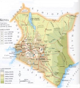
| location: East Africa |
| time zone: +3 UT |
| surface (land) area: 582646 sq.km = 224916 sq.mi //; - area incl. inland waters: sq.km = sq.mi |
| geographical position in extreme co-ordinates: North: 5° N / South: 5° S / East: 42° E / West: 34° E |
| borders (land): Tanzania, Uganda, Sudan, Ethiopia, Somalia |
| borders (coastline): Indian Ocean |
| climate: tropical: partly hot and humid, or: dry, temperate |
| Government |
| independent since: 1963-12-12 |
| type of government: republic |
| capital: Nairobi |
| administrative division: province (7), special area (1) |
| Population |
| population according to the latest census (1999): 28686,607 |
| total population according to the estimate of midyear 2000: 30339,770; or: 30092,000 // -; 2001: 29904,000 |
| population density: 51 per sq.km = 133 per sq.mi |
| population growth: 4% //; - doubling time: 28 years |
| birth rate: 28 - 47 per 1000 |
| death rate: 10 - 14 per 1000 |
| fertility rate: 7 children per female |
| maternal mortality: 170 per 100,000 |
| infant mortality (1-4 years): 55 per 1000 |
| life expectancy: 48 - 61 years (male: 47 - 59; female: 48 - 63) |
| age breakdown: 0-14 years: 50% //; - 15-59 years: 46% //; - 60+ years: 4% |
| urbanisation: 33% //; - urbanisation growth: 7% |
| percentage of urban population in the greatest city: 57% |
| Ethnic composition, language, religion |
| ethnic groups: Kikuyu 17%; Luhya 12%; Luo 11%; Kalenjin 10%; Kamba 10%; Kisii 6%; Meru 5%; Mijikenda 5%; Masai 2%; Turkana 1%; other: 21% |
| languages: Swahili, English (both official); Kikuyu, plus over 200 tribal indigenous languages |
| religious affiliation: Christian 48 - 66% (Protestant 28-38, Roman Catholic 20-28); African indigenous 18 - 30%; Muslim 6%; other 2% |
| Health |
| daily food intake: 1968 calories per capita |
| population with access to safe water: 53% |
| people per physician: 6000 |
| people per hospital bed: |
| Education, literacy |
| school enrolment: primary education 6-11 years: 93% |
| school enrolment: secondary education: 23% |
| school enrolment: tertiary education 20-24 years: 2% |
| adult literacy: 69% (male: %; female: %) [later found total figure: 78 - 82%] |
| Economy and infrastructure |
| Economy and trade |
| currency: Kenya shilling = 100 cents |
| annual inflation rate: 14% |
| population below poverty line: 42% |
| Gross Domestic Product: USD 1190 per capita |
| GNI USD 350 per capita //; - [ppp: 1010] |
| GDP growth: -0,5% |
| income: USD 340 per capita |
| import: USD 1696 per capita //; - export: USD 1392 per capita |
| trade: USD 130 per capita //; - or 47% of GDP |
| trade partners: GB JP DE UG UA |
| human development index: 0,514 //; - position of the country in the world no.: 123 |
| female labour force: 46% |
| unemployment: % |
| tourism: 0,9 million |
| Economic activities in agriculture, fisheries, industry, mining, services, energy |
| land use: arable land: 4% //; - grass land: 67% //; - wooded area: 4% //; - arid land and desert: ca 20% |
| agriculture: labour force: 81% //; - part of agriculture in GDP: 27% |
| agricultural products: maize, millet, cassava, beans, pyrethrum, tea, coffee, sugar, cattle, sisal, cut flowers, hides |
| livestock (million): camels: 0,8 / cattle: 13,8 / goats: 9,6 / pigs: 0,2 / poultry: 31 / sheep: 7 |
| fish catch: 161183 - 205287 metric tonnes |
| industry: labour force: 7% //; - part of industry in GDP: 22% |
| industrial products: agriculture, oil refining, food processing, cement, light industry |
| mining products: soda ash, fluorspar, limestone, rubies, gold, vermiculite, garnets, salt |
| CO2 emission per capita: 0,3 |
| services: labour force: 12% //; - part of services in GDP: 51% |
| energy use (kg per capita): 499 |
| electricity use (per capita): 126 |
| annual water use (per capita): 50 |
| Traffic, communication |
| road network: 54700, or 63663 km //; - of which paved: 14% //; - of which are motorways: 0 km |
| vehicles: 5 per 1000 |
| railways: 2733, or 3034 km //; - railways passenger/km: 464, or 1276 |
| navigable inland waterways: 0 km |
| ownership telephone: 9 - 10 per 1000 |
| ownership radio receivers: 103 - 108 per 1000 |
| ownership tv-sets: 18 - 26 per 1000 |
| newspaper circulation: 13 per 1000 |
| persons per post office: 26000 |
| personal computers: 5 per 1000 |
| Some physical landmarks |
| mountains: Kirinyaga (Mt. Kenya) 5199 m, Mt. Elgon 4321, Sattimma 3994 |
| lowest point: sea level |
| lakes (natural): Lake Victoria, Lake Turkana (Rudolf), Lake Magadi, Lake Naivasha |
| lakes (artificial reservoirs): Masinga Reservoir |
| lakes (deepest): unknown |
| rivers: Tana, Galana, Athi, Ewaso Ngiro, Milgis, Kerjo |
| canals: none, or unknown |
| waterfalls: none, or unknown |
| caves: longest system: none, or unknown / deepest: |
| islands: Mfanganu, Rusinga (both in Lake Victoria); Central Island, South Island (both in Lake Turkana) |
| deserts: Chalbi |
| other natural features: |
| Additional remarks, especially on the statistical information |
| other important features: |
| apart from physical landmarks most of the above figures are changeable, in most cases they date from the 1990's |
| primary sources used for the general information: |
| BB CA EV PW WA WB WR, and some national statistical yearbooks |
| particulars concerning population data: |
 To the page containing the population growth statistics of the country
 To the page containing the historical population growth statistics of the provinces
 To the page containing urban historical population statistics
 Back to the homepage of this website: POPULATION STATISTICS
Internet website:Latest modification of this page on 2004-02-20 by Jan Lahmeyer
© "populstat" site: Jan Lahmeyer