All countries of the world listed from A-Z:

or choose from the countries per continent below:


 |  |  |  |  |  |
 | GABONgeneral data of the country |
| General useful information |
| Note: some data are of constant value, while other are due to changes, fluctuations etc. |
| Nation and population |
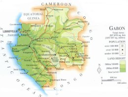
| official name (short form): Gabon |
| country code ISO: GA //; - FIPS: GB |
| location: Central Africa |
| time zone: +1 UT |
| surface (land) area: 267667 sq.km = 103344 sq.mi //; - area incl. inland waters: sq.km = sq.mi |
| geographical position in extreme co-ordinates: North: 2° N / South: 4° S / East: 14° E / West: 9° E |
| borders (land): Equatorial Guinea, Cameroon, Congo Brazzaville |
| borders (coastline): Atlantic Ocean |
| climate: tropical |
| Government |
| independent since: 1960-08-17 |
| type of government: republic |
| capital: Libreville |
| administrative division: province (9) |
| Population |
| population according to the latest census (1993): 1011,710; or: 1014,976 |
| total population according to the estimate of midyear 2000: 1208,436; or: 1230,000 // - ; 2001: 1262,000 |
| population density: 4,6 per sq.km = 12 per sq.mi |
| population growth: 3% //; - doubling time: 32 years |
| birth rate: 27 - 43 per 1000 |
| death rate: 16 - 17 per 1000 |
| fertility rate: 6 children per female |
| maternal mortality: 124 per 100,000 |
| infant mortality (1-4 years): 94 per 1000 |
| life expectancy: 50 - 53 years (male: 48 - 52; female: 51 - 55) [differences depend on sources used] |
| age breakdown: 0-14 years: 32% //; - 15-59 years: 59% //; - 60+ years: 9% |
| urbanisation: 46 - 81% //; - urbanisation growth: % |
| percentage of urban population in the greatest city: 66% |
| Ethnic composition, language, religion |
| ethnic groups: Fang 32%; Mpongwe 15%; Mbete 14%; Eshira-Epunu 12%; Bareke [Batéké]; Pygmee 1% |
| languages: French, Bantu languages (especially Fang, Batéké) |
| religious affiliation: Roman Catholic 50%; Protestant 18%; traditional beliefs 19%; other 13% |
| Health |
| daily food intake: 2560 calories per capita |
| population with access to safe water: 67% |
| people per physician: 2790 |
| people per hospital bed: |
| Education, literacy |
| school enrolment: primary education 6-11 years: 70% |
| school enrolment: secondary education: 48% |
| school enrolment: tertiary education 20-24 years: 14% |
| adult literacy: 63% (male: 74%; female: 53%) |
| Economy and infrastructure |
| Economy and trade |
| currency: CFA franc = 100 centimes |
| annual inflation rate: 6% |
| population below poverty line: % |
| Gross Domestic Product: USD 3759 per capita |
| GNI USD 3190 per capita //; - [ppp: 5360] |
| GDP growth: 0,1% |
| income: USD 3780 per capita |
| import: USD 681 per capita //; - export: USD 1041 per capita |
| trade: USD 2094 per capita //; - or 89% of GDP |
| trade partners: FR US DE JP CA GB ES |
| human development index: 0,617 //; - position of the country in the world no.: 109 |
| female labour force: 45% |
| unemployment: 20% |
| tourism: 0,15 million |
| Economic activities in agriculture, fisheries, industry, mining, services, energy |
| land use: arable land: 2% //; - grass land: 18% //; - wooded area: 78% //; - arid land and desert: % |
| agriculture: labour force: 76% //; - part of agriculture in GDP: 9% |
| agricultural products: timber, roots & tubers (cassava, yams, taro), plantains, sugarcane, maize, cocoa, coffee |
| livestock (1000s): cattle: 39 / goats: 91 / horses: / pigs: 213 / poultry: 3200 / sheep: 198 |
| fish catch: 44772 - 52882 metric tonnes |
| industry: labour force: 11% //; - part of industry in GDP: 45% |
| industrial products: petroleum products, textiles, food and beverages, wood products |
| mining products: oil, manganese, uranium, gold, iron, natural gas |
| CO2 emission per capita: 0,2 |
| services: labour force: 14% //; - part of services in GDP: 46% |
| energy use (kg per capita): 1342 |
| electricity use (per capita): 700 |
| annual water use (per capita): 57 |
| Traffic, communication |
| road network: 7535 - 7800 km //; - of which paved: 10% //; - of which are motorways: 0 km |
| vehicles: 14 per 1000 |
| railways: 668 - 814 km //; - railways passenger/km: 34 |
| navigable inland waterways: 1600 km |
| ownership telephone: 24 - 32 per 1000 |
| ownership radio receivers: 119 - 183 per 1000 |
| ownership tv-sets: 35 - 136 per 1000 |
| newspaper circulation: 16 - 34 per 1000 |
| persons per post office: 19300 |
| personal computers: 10 per 1000 |
| Some physical landmarks |
| mountains: Mont Milondo 1020 m, Mont Iboundji 980 |
| lowest point: sea level |
| lakes (natural): unknown |
| lakes (artificial reservoirs): none |
| lakes (deepest): - |
| rivers: Ogooué and its tributaries like Ngounié and Ivindo |
| canals: none |
| waterfalls: unknown |
| caves: longest system: unknown / deepest: |
| islands: none |
| deserts: none |
| other natural features: |
| Additional remarks, especially on the statistical information |
| other important features: |
| apart from physical landmarks most of the above figures are changeable, in most cases they date from the 1990's |
| composition of ethnic groups varies per source |
| primary sources used for the general information: |
| BB CA EV PW WA WB WR, and some national statistical yearbooks |
| particulars concerning population data: |
 To the page containing the population growth statistics of the country
 To the page containing the historical population growth statistics of the provinces
 To the page containing urban historical population statistics
 Back to the homepage of this website: POPULATION STATISTICS
Internet website:Latest modification of this page on 2004-02-13 by Jan Lahmeyer
© "populstat" site: Jan Lahmeyer