All countries of the world listed from A-Z:

or choose from the countries per continent below:


 |  |  |  |  |  |
 | WESTERN SAMOAgeneral data of the country |
| General useful information |
| Note: some data are of constant value, while other are due to changes, fluctuations etc. |
| Nation and population |
| official name (short form): Western Samoa |
| country code ISO: WS //; - FIPS: WS |
| location: Pacific Ocean |
| time zone: -11 UT |
| surface (land) area: 2831 sq.km = 1093 sq.mi //; - area incl. inland waters: sq.km = sq.mi |
| geographical position in extreme co-ordinates: North: 10° S / South: 15° S / East: 171° W / West: 175° W |
| borders (land): none |
| borders (coastline): Pacific Ocean |
| climate: tropical oceanic |
| Government |
| independent since: 1962-01-01 |
| type of government: constitutional monarchy |
| capital: Apia |
| administrative division: district (11) |
| Population |
| population according to the latest census (1991): 161,298 |
| total population according to the estimate of midyear 2000: 179,466 /-; 2001: 179,085 |
| population density: 63 per sq.km = 164 per sq.mi |
| population growth: 3% //; - doubling time: 23 years |
| birth rate: 15 - 36 per 1000 |
| death rate: 5,5 - 6 per 1000 |
| fertility rate: 4 children per female |
| maternal mortality: per 100,000 |
| infant mortality (1-4 years): 60 per 1000 |
| life expectancy: 69 years (male: 67; female: 72) |
| age breakdown: 0-14 years: 41% //; - 15-59 years: 53% //; - 60+ years: 6% |
| urbanisation: 21% //; - urbanisation growth: % |
| percentage of urban population in the greatest city: % |
| Ethnic composition, language, religion |
| ethnic groups: Samoan 93%; mixed European and Polynesian |
| languages: Samoan (Polynesian), English (both official) |
| religious affiliation: Christian: Congregational 43%; Roman Catholic 21%; Methodist 17%; Mormon 10% |
| Health |
| daily food intake: calories per capita |
| population with access to safe water: 68 - 99% |
| people per physician: 2682 |
| people per hospital bed: |
| Education, literacy |
| school enrolment: primary education 6-11 years: 95% |
| school enrolment: secondary education: 52% |
| school enrolment: tertiary education 20-24 years: 2% |
| adult literacy: virtually 100% (male: %; female: %) |
| Economy and infrastructure |
| Economy and trade |
| currency: tala = 100 sene |
| annual inflation rate: 3% |
| population below poverty line: % |
| Gross Domestic Product: USD 970 per capita |
| GNI USD 1450 per capita //; - [ppp: 5050] |
| GDP growth: 2% |
| income: USD 930 per capita |
| import: USD 131 per capita //; - export: USD 50 per capita |
| trade: USD 629 per capita //; - or 51% of GDP |
| trade partners: NZ AU FJ JP US DE SG AS |
| human development index: 0,701 //; - position of the country in the world no.: 96 |
| female labour force: 19% |
| unemployment: % |
| tourism: 0,09 million |
| Economic activities in agriculture, fisheries, industry, mining, services, energy |
| land use: arable land: 43% //; - grass land: 0,4% //; - wooded area: 47% //; - arid land and desert: % |
| agriculture: labour force: 60% //; - part of agriculture in GDP: 51% |
| agricultural products: coconuts, taro, copra, bananas, papayas, pineapples, mangoes, avocados, timber, yams, fish |
| livestock (thousands): asses: 7 / cattle: 26 / pigs: 179 / poultry: 350 |
| fish catch: metric tonnes |
| industry: labour force: 3% //; - part of industry in GDP: 12% |
| industrial products: food & beverages, coconut cream, coconut oil |
| mining products: none |
| CO2 emission per capita: 0,8 |
| services: labour force: 37% //; - part of services in GDP: 37% |
| energy use (kg per capita): 433 |
| electricity use (per capita): |
| annual water use (per capita): |
| Traffic, communication |
| road network: 781, or 2085 km //; - of which paved: 42% //; - of which are motorways: 0 km |
| vehicles: 11 per 1000 |
| railways: 0 km //; - railways passenger/km: - |
| navigable inland waterways: 0 km |
| ownership telephone: 46 - 49 per 1000 |
| ownership radio receivers: 418 - 1035 per 1000 |
| ownership tv-sets: 30 - 69 per 1000 |
| newspaper circulation: per 1000 |
| persons per post office: 4360 |
| personal computers: 6 per 1000 |
| Some physical landmarks |
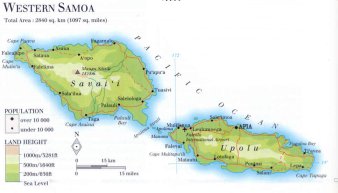
| mountains: Mauga Silisili 1858 m, nameless peak East of M.S.: 1831; M. Loa 1176, Mauga Fito (Va'aifetu) 1116 |
| lowest point: sea level |
| lakes (natural): none, or unknown |
| lakes (artificial reservoirs): none, or unknown |
| lakes (deepest): unknown |
| rivers: some small rivers to drain the mountain slopes |
| canals: none, or unknown |
| waterfalls: none, or unknown |
| caves: longest system: none, or unknown / deepest: |
| islands: Savai'i, Upolu |
| deserts: none |
| other natural features: |
| Additional remarks, especially on the statistical information |
| other important features: |
| apart from physical landmarks most of the above figures are changeable, in most cases they date from the 1990's |
| primary sources used for the general information: |
| BB CA EV PW WA WB WR, and some national statistical yearbooks |
| particulars concerning population data: |
 To the page containing the population growth statistics of the country
 To the page containing the historical population growth statistics of the provinces
 To the page containing urban historical population statistics
 Back to the homepage of this website: POPULATION STATISTICS
Latest modification of this page on 2004-03-14 by Jan Lahmeyer
© "populstat" site: Jan Lahmeyer