All countries of the world listed from A-Z:

or choose from the countries per continent below:


 |  |  |  |  |  |
 | TONGAgeneral data of the country |
| General useful information |
| Note: some data are of constant value, while other are due to changes, fluctuations etc. |
| Nation and population |
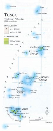
| official name (short form): Tonga |
| country code ISO: TO //; - FIPS: TN |
| location: South Pacific Ocean |
| time zone: +13 UT |
| surface (land) area: 750 sq.km = 289 sq.mi //; - area incl. inland waters: sq.km = sq.mi |
| geographical position in extreme co-ordinates: North: 15° S / South: 23° S / East: 171° W / West: 180° W |
| borders (land): none |
| borders (coastline): Pacific Ocean |
| climate: tropical oceanic |
| Government |
| independent since: 1820 ; 1970-06-04 |
| type of government: constitutional monarchy |
| capital: Nuku'alofa |
| administrative division: 169 islands in 5 groups |
| Population |
| population according to the last two censuses: (1986): 94,649; (1996): 97,784 |
| total population according to the estimate of midyear 2000: 100,000; or: 102,321 /-; 2001: 99,000; or: 104,227 |
| population density: 133 per sq.km = 345 per sq.mi |
| population growth: 0,7% //; - doubling time: 32 years |
| birth rate: 24 - 29 per 1000 |
| death rate: 4 - 6 per 1000 |
| fertility rate: 3 children per female |
| maternal mortality: per 100,000 |
| infant mortality (1-4 years): 23 per 1000 |
| life expectancy: 69 years (male: 66; female: 71) |
| age breakdown: 0-14 years: 37% //; - 15-59 years: % //; - 60+ years: % |
| urbanisation: % //; - urbanisation growth: % |
| percentage of urban population in the greatest city: % |
| Ethnic composition, language, religion |
| ethnic groups: Tongan 95,5% (Polynesian); part Tongan 2,8%; other 1,7% |
| languages: Tongan, English (both official) |
| religious affiliation: Free Weslyan 43%; Roman Catholic 16%; Mormon 12%; Free Church of Tonga 11% |
| Health |
| daily food intake: calories per capita |
| population with access to safe water: 100% |
| people per physician: 320 |
| people per hospital bed: |
| Education, literacy |
| school enrolment: primary education 6-11 years: 54% |
| school enrolment: secondary education: 23% |
| school enrolment: tertiary education 20-24 years: 6% |
| adult literacy: 93% (male: %; female: %) |
| Economy and infrastructure |
| Economy and trade |
| currency: Tongan pa'anga = 100 seniti |
| annual inflation rate: 2% |
| population below poverty line: % |
| Gross Domestic Product: USD 1500 per capita |
| GNI USD 1660 per capita //; - [ppp: ] |
| GDP growth: 2% |
| income: USD 1100 per capita |
| import: USD 69 per capita //; - export: USD 14 per capita |
| trade: USD 811 per capita //; - or 52% of GDP |
| trade partners: NZ AU JP US FJ |
| human development index: //; - position of the country in the world no.: |
| female labour force: 33% |
| unemployment: % |
| tourism: 0,035 million |
| Economic activities in agriculture, fisheries, industry, mining, services, energy |
| land use: arable land: 67% //; - grass land: 6% //; - wooded area: 11% //; - arid land and desert: % |
| agriculture: labour force: 45% //; - part of agriculture in GDP: 41% |
| agricultural products: coconuts, cassava, passion fruit, yams, taor, sweet potatoes, vegetables, copra, bananas, vanilla beans |
| livestock (1000s): cattle: 9 / goats: 14-16 / hogs: 81 / horses: 11 / pigs: 81 / poultry: 266 |
| fish catch: metric tonnes |
| industry: labour force: 4% //; - part of industry in GDP: 19% |
| industrial products: food products, chemicals, textile, wood and timber |
| mining products: coral, sand |
| CO2 emission per capita: 1,2 |
| services: labour force: 51% //; - part of services in GDP: 40% |
| energy use (kg per capita): 27 |
| electricity use (per capita): |
| annual water use (per capita): |
| Traffic, communication |
| road network: 386, or 680 km //; - of which paved: 27, or 76% //; - of which are motorways: 0 km |
| vehicles: 19 or 75 per 1000 |
| railways: 0 km //; - railways passenger/km: - |
| navigable inland waterways: 0 km |
| ownership telephone: 67 - 93 per 1000 |
| ownership radio receivers: 400 - 619 per 1000 |
| ownership tv-sets: 21 per 1000 |
| newspaper circulation: 73 per 1000 |
| persons per post office: 55600 |
| personal computers: per 1000 |
| Some physical landmarks |
| mountains: Kao 1014 m |
| lowest point: sea level |
| lakes (natural): some lagoons |
| lakes (artificial reservoirs): none, or unknown |
| lakes (deepest): unknown |
| rivers: some short ones to drain the mountain slopes |
| canals: none, or unknown |
| waterfalls: none, or unknown |
| caves: longest system: none, or unknown / deepest: |
| islands: see the separate file of the administrative division |
| deserts: none |
| other natural features: |
| Additional remarks, especially on the statistical information |
| other important features: |
| apart from physical landmarks most of the above figures are changeable, in most cases they date from the 1990's |
| primary sources used for the general information: |
| BB CA EV PW WA WB WR, and some national statistical yearbooks |
| particulars concerning population data: |
| the estimates for recent poulation figures always tend to be higher than the census results |
 To the page containing the population growth statistics of the country
 To the page containing the historical population growth statistics of the provinces
 To the page containing urban historical population statistics
 Back to the homepage of this website: POPULATION STATISTICS
Latest modification of this page on 2004-03-10 by Jan Lahmeyer
© "populstat" site: Jan Lahmeyer