All countries of the world listed from A-Z:

or choose from the countries per continent below:


 |  |  |  |  |  |
 | MACAU[MACAO, AOMEN] : general data of the country |
| General useful information |
| Note: some data are of constant value, while other are due to changes, fluctuations etc. |
| Nation and population |
| official name (short form): Macau ; Aomen |
| country code ISO: MO //; - FIPS: MC |
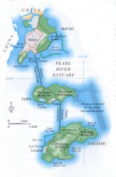
| location: East Asia |
| time zone: +8 UT |
| surface (land) area: 21 sq.km = 8 sq.mi //; - area incl. inland waters: sq.km = sq.mi |
| geographical position in extreme co-ordinates: North: 22°13'05" N / South: 22°06'39" N / East: 113°35'43" E / West: 113°31'36" E |
| borders (land): China, prov. Guangdong |
| borders (coastline): South China Sea / length of coast line: 40,8 km (peninsula 13,3; islands 27,5) |
| climate: subtropical monsoon |
| Government |
| dependency: from 1557 until 1999-12-20 colony of Portugal, since then special territory within China |
| type of government: special administrative region within China |
| capital: Macau (Macao) |
| administrative division: no further division |
| Population |
| population according to the latest census (1991): 339,464 |
| total population according to the estimate of midyear 2000: 445,594; 2001: 453,733 |
| population density: 21428 per sq.km = 55500 per sq.mi |
| population growth: % //; - doubling time: years |
| birth rate: 17 per 1000 |
| death rate: 3 per 1000 |
| fertility rate: 2 children per female |
| maternal mortality: per 100,000 |
| infant mortality (1-4 years): 6 per 1000 |
| life expectancy: 77 years (male: 75; female: 79) |
| age breakdown: 0-14 years: 24% //; - 15-59 years: 66% //; - 60+ years: 10% |
| urbanisation: 99% //; - urbanisation growth: % |
| percentage of urban population in the greatest city: 100% |
| Ethnic composition, language, religion |
| ethnic groups: Chinese 68 - 95%; Portuguese 3 - 27% |
| languages: Chinese (Cantonese), Portuguese |
| religious affiliation: Buddhist 45%; Roman Catholic 7% |
| Health |
| daily food intake: 2471 calories per capita |
| population with access to safe water: % |
| people per physician: 1167 |
| people per hospital bed: 396 |
| Education, literacy |
| school enrolment: primary education 6-11 years: % |
| school enrolment: secondary education: % |
| school enrolment: tertiary education 20-24 years: % |
| adult literacy: 90 - 93% (male: %; female: %) |
| Economy and infrastructure |
| Economy and trade |
| currency: Pataca = 100 avos (until 2000?) / since then the Chines currency: Renminbi yuan |
| annual inflation rate: 4% |
| population below poverty line: % |
| Gross Domestic Product: USD 16160 per capita |
| GNI USD 14580 per capita //; - [ppp: 18190] |
| GDP growth: 0,4% |
| income: USD 6000 per capita |
| import: USD 2019 per capita //; - export: USD 2018 per capita |
| trade: USD 6992 per capita //; - or 77% of GDP |
| trade partners: CN JP PT |
| human development index: //; - position of the country in the world no.: |
| female labour force: 42% |
| unemployment: % |
| tourism: 7 million |
| Economic activities in agriculture, fisheries, industry, mining, services, energy |
| land use: arable land: % //; - grass land: % //; - wooded area: 2% //; - arid land and desert: % |
| agriculture: labour force: < 1% //; - part of agriculture in GDP: 1% |
| agricultural products: meat, fish |
| livestock (1000s): asses: / camels: / cattle: / goats: / horses: / pigs: / poultry: 420 / sheep: |
| fish catch: 1500 metric tonnes |
| industry: labour force: 33% //; - part of industry in GDP: 34% |
| industrial products: diverse range of products |
| mining products: none |
| CO2 emission per capita: 3,8 |
| services: labour force: 67% //; - part of services in GDP: 65% |
| energy use (kg per capita): 857 |
| electricity use (per capita): 3370 |
| annual water use (per capita): |
| Traffic, communication |
| road network: 341 km //; - of which paved: 100% //; - of which are motorways: 0 km |
| vehicles: per 1000 |
| railways: 0 km //; - railways passenger/km: - |
| navigable inland waterways: 0 km |
| ownership telephone: 361 - 408 per 1000 |
| ownership radio receivers: 356 - 591 per 1000 |
| ownership tv-sets: 113 per 1000 |
| newspaper circulation: 591 per 1000 |
| persons per post office: 34500 |
| personal computers: 94 - 137 per 1000 |
| Some physical landmarks |
| mountains: Coloane 170,6 m, Taipa Grande 158,9, Ponto Central 136 |
| lowest point: sea level |
| lakes (natural): none |
| lakes (artificial reservoirs): none |
| lakes (deepest): |
| rivers: none |
| canals: unknown |
| waterfalls: none |
| caves: longest system: none / deepest: |
| islands: Coloane, Taipa |
| deserts: none |
| other natural features: |
| Additional remarks, especially on the statistical information |
| other important features: |
| apart from physical landmarks most of the above figures are changeable, in most cases they date from the 1990's |
| the data, which are effected by changes, are mostly prior to 1999, when Macau was reverted to China |
| primary sources used for the general information: |
| BB CA EV PW WA WB WR, and some national statistical yearbooks |
| particulars concerning population data: |
 CHINA : the file of the administrative division ; under municipality : Macau (SAR).
 To the page containing the population growth statistics of the country
 Back to the homepage of this website: POPULATION STATISTICS
Latest modification of this page on 2004-02-23 by Jan Lahmeyer
© "populstat" site: Jan Lahmeyer