All countries of the world listed from A-Z:

or choose from the countries per continent below:


 |  |  |  |  |  |
 | JORDAN[Urdunn] : |
| General useful information |
| Note: some data are of constant value, while other are due to changes, fluctuations etc. |
| Nation and population |
| official name (short form): Al Urdun |
| country code ISO: JO //; - FIPS: JO |
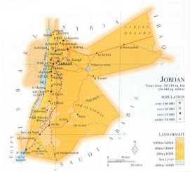
| location: Southwest Asia, Middle East |
| time zone: +2 UT* [*= applying daylight saving time] |
| surface (land) area: 88946 sq.km = 34342 sq.mi //; - area incl. inland waters: sq.km = sq.mi |
| geographical position in extreme co-ordinates: North: 33° N / South: 29° N / East: 39° E / West: 35° E |
| borders (land): Syria, Iraq, Saudi Arabia, Israel, [Palestine] |
| borders (coastline): Gulf of Aqaba (Red Sea - Indian Ocean) |
| climate: tropical arid |
| Government |
| independent since: 1946-05-25 ; 1949 |
| type of government: constitutional monarchy |
| capital: 'Ammân |
| administrative division: muhafaza [governorate] (12) |
| Population |
| population according to the latest census (1994): 4095,579 |
| total population according to the estimate of midyear 2000: 4998,564; or: 4887,000 // -; 2001: 5300,000 |
| population density: 56 per sq.km = 146 per sq.mi |
| population growth: 2,6% //; - doubling time: 23 years |
| birth rate: 25 - 39 per 1000 |
| death rate: 3- 5 per 1000 |
| fertility rate: 5 children per female |
| maternal mortality: per 100,000 |
| infant mortality (1-4 years): 34 per 1000 |
| life expectancy: 77 years (male: 75; female: 80) |
| age breakdown: 0-14 years: 45% //; - 15-59 years: 51% //; - 60+ years: 4% |
| urbanisation: 74% //; - urbanisation growth: 5% |
| percentage of urban population in the greatest city: 37% |
| Ethnic composition, language, religion |
| ethnic groups: Arab 98% (of which half are Palestinian); Circassian 1%; Armenian 1% |
| languages: Arabic (official); English |
| religious affiliation: Sunnî Muslim 93-97%; Christian 3-5% |
| Health |
| daily food intake: 2791 calories per capita |
| population with access to safe water: 89% |
| people per physician: 625 |
| people per hospital bed: 546 |
| Education, literacy |
| school enrolment: primary education 6-11 years: 100% |
| school enrolment: secondary education: 74% |
| school enrolment: tertiary education 20-24 years: 1% |
| adult literacy: 80% (male: %; female: %) [for total a later figure found: 90%] |
| Economy and infrastructure |
| Economy and trade |
| currency: Jordan dinar = 1000 fils |
| annual inflation rate: 3% |
| population below poverty line: 12% |
| Gross Domestic Product: USD 1510 per capita |
| GNI USD 1710 per capita //; - [ppp: 3950] |
| GDP growth: 1% |
| income: USD 1120 per capita |
| import: USD 3723 per capita //; - export: USD 1782 per capita |
| trade: USD 825 per capita //; - or 77% of GDP |
| trade partners: US IQ ID SA DE FR IN |
| human development index: 0,714 //; - position of the country in the world no.: 88 |
| female labour force: 25% |
| unemployment: 16% |
| tourism: 1,4 million |
| Economic activities in agriculture, fisheries, industry, mining, services, energy |
| land use: arable land: 4% //; - grass land: 9% //; - wooded area: 1% //; - arid land and desert: ca 80% |
| agriculture: labour force: 10% //; - part of agriculture in GDP: 7% |
| agricultural products: fresh food and fruit; some grains and olives |
| livestock (1000s): asses: 18 / camels: 18 / cattle: 65 / goats: 640 / poultry: 23500 / sheep: 1896 |
| fish catch: metric tonnes |
| industry: labour force: 26% //; - part of industry in GDP: 26% |
| industrial products: of some small importance are oil refining, cement, light manufacturing |
| mining products: phosphates, potash |
| CO2 emission per capita: 3,0 |
| services: labour force: 26% //; - part of services in GDP: 26% |
| energy use (kg per capita): 1028 |
| electricity use (per capita): 1207 |
| annual water use (per capita): 173 |
| Traffic, communication |
| road network: 5865, or 7133 km //; - of which paved: 100% //; - of which are motorways: 0 km |
| vehicles: 46 per 1000 |
| railways: 618, or 677 km //; - railways passenger/km: 6 |
| navigable inland waterways: 0 km |
| ownership telephone: 73 - 87 per 1000 |
| ownership radio receivers: 234 - 287 per 1000 |
| ownership tv-sets: 86 - 175 per 1000 |
| newspaper circulation: 48 per 1000 |
| persons per post office: 4190 |
| personal computers: 23 per 1000 |
| Some physical landmarks |
| mountains: Jabal Ramm 1754 m, Rujm Tal'at al Jamâ'ah 1743, Jabal Mabrak 1727 |
| lowest point: Dead Sea (at 408 m below sea level) |
| lakes (natural): Dead Sea, Wahat al Azraq |
| lakes (artificial reservoirs): unknown |
| lakes (deepest): Dead Sea (?) |
| rivers: Jordan |
| canals: none, or unknown |
| waterfalls: none, or unknown |
| caves: longest system: unknown / deepest: |
| islands: none |
| deserts: Ard as Sawwan (se), Syrian desert (ne) |
| other natural features: |
| Additional remarks, especially on the statistical information |
| other important features: |
| apart from physical landmarks most of the above figures are changeable, in most cases they date from the 1990's |
| primary sources used for the general information: |
| BB CA EV PW WA WB WR, and some national statistical yearbooks |
| particulars concerning population data: |
 To the page containing the population growth statistics of the country
 To the page containing the historical population growth statistics of the provinces
 To the page containing urban historical population statistics
 Back to the homepage of this website: POPULATION STATISTICS
Internet website: Internet website:Latest modification of this page on 2004-02-20 by Jan Lahmeyer
© "populstat" site: Jan Lahmeyer