All countries of the world listed from A-Z:

or choose from the countries per continent below:


 |  |  |  |  |  |
 | SOMALIAgeneral data of the country |
| General useful information |
| Note: some data are of constant value, while other are due to changes, fluctuations etc. |
| Nation and population |
| official name (short form): Soomaaliya |
| country code ISO: SO //; - FIPS: SO |
| location: Northeast Africa |
| time zone: +3 UT |
| surface (land) area: 637660 sq.km = 246200 sq.mi //; - area incl. inland waters: sq.km = sq.mi |
| geographical position in extreme co-ordinates: North: 12° N / South: 2° S / East: 52° E / West: 41° E |
| borders (land): Djibouti, Ethiopia, Kenya |
| borders (coastline): Indian Ocean |
| climate: tropical arid, northern coast hot and humid |
| Government |
| independent since: 1960-07-01 |
| type of government: republic |
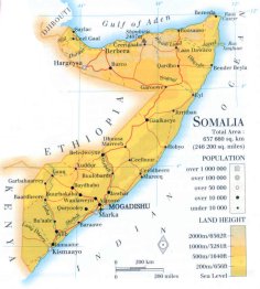
| capital: Muqdisho (Mogadishu) |
| administrative division: region (16) |
| Population |
| population according to the last two censuses (1975): 4089,203 /-; (1986): 7114,431 |
| total population according to the estimate of midyear 2000: 7253,137; or: 8778,000 /-; 2001: 10390,000 |
| population density: 14 per sq.km = 36 per sq.mi |
| population growth: 3% //; - doubling time: 22 years |
| birth rate: 45 - 47 per 1000 |
| death rate: 13 - 18 per 1000 |
| fertility rate: 7 children per female |
| maternal mortality: 1100 per 100,000 |
| infant mortality (1-4 years): 117 - 123 per 1000 |
| life expectancy: 47 years (male: 45; female: 48) |
| age breakdown: 0-14 years: 47% //; - 15-59 years: 49% //; - 60+ years: 4% |
| urbanisation: 27 - 36% //; - urbanisation growth: 5% |
| percentage of urban population in the greatest city: 34% |
| Ethnic composition, language, religion |
| ethnic groups: Somali 98,3%; Arab 1,2%; Bantu 0,4%; other 0,1% |
| languages: Somali (official); Arab, English, Italian |
| religious affiliation: Sunnî Muslim 99,8%; Christian 0,1%; other 0,1% |
| Health |
| daily food intake: 1531 calories per capita |
| population with access to safe water: 37% |
| people per physician: 19000 |
| people per hospital bed: |
| Education, literacy |
| school enrolment: primary education 6-11 years: 50% |
| school enrolment: secondary education: 7% |
| school enrolment: tertiary education 20-24 years: 1% |
| adult literacy: 24% (male: 43%; female: 14%) |
| Economy and infrastructure |
| Economy and trade |
| currency: Somali shilling = 100 cents |
| annual inflation rate: % |
| population below poverty line: % |
| Gross Domestic Product: USD 150 per capita |
| GNI USD 110 per capita //; - [ppp: ] |
| GDP growth: % |
| income: USD 150 per capita |
| import: USD 228 per capita //; - export: USD 44 per capita |
| trade: USD 35 per capita //; - or % of GDP |
| trade partners: SA IT GB KE DE |
| human development index: unknown //; - position of the country in the world no.: one of the lowest of the world |
| female labour force: 43 - 49% |
| unemployment: % |
| tourism: 0,01 million |
| Economic activities in agriculture, fisheries, industry, mining, services, energy |
| land use: arable land: 2% //; - grass land: 69% //; - wooded area: 14 - 25% //; - arid land and desert: % |
| agriculture: labour force: 76% //; - part of agriculture in GDP: 65% |
| agricultural products: fruits, sugarcane, maize, sorghum, bananas, sesame seed, beans, dates, fish, mangoes |
| livestock (million): camels: 6,1 / cattle: 5,1 / goats: 12,3 / pigs: 0,004 / poultry: 3,2 / sheep: 13,1 |
| fish catch: 15700 - 20250 metric tonnes |
| industry: labour force: 8% //; - part of industry in GDP: 10% |
| industrial products: hides & skins, food processing, |
| mining products: sepiolote, salt, tin, zinc, copper, gypsum, manganese, uranium, iron, bauxite |
| CO2 emission per capita: |
| services: labour force: 16% //; - part of services in GDP: 25% |
| energy use (kg per capita): 7 |
| electricity use (per capita): |
| annual water use (per capita): 98 |
| Traffic, communication |
| road network: 22218, or 23700 km //; - of which paved: 12% //; - of which are motorways: 0 km |
| vehicles: 1 per 1000 |
| railways: 0 km //; - railways passenger/km: - |
| navigable inland waterways: 0 km |
| ownership telephone: 1,7 - 2 per 1000 |
| ownership radio receivers: 41 - 53 per 1000 |
| ownership tv-sets: 13 - 18 per 1000 |
| newspaper circulation: 1 per 1000 |
| persons per post office: |
| personal computers: per 1000 |
| Some physical landmarks |
| mountains: Buuraha Surud Cad (Shimbiris) 2407 m, Baxaya 2200, Bur Afaf 2073, Qar Wager 2000 |
| lowest point: sea level |
| lakes (natural): none, or unknown |
| lakes (artificial reservoirs): none, or unknown |
| lakes (deepest): unknown |
| rivers: Juba, Shebeli and lots of wadi rivers |
| canals: none, or unknown |
| waterfalls: none, or unknown |
| caves: longest system: none, or unknown / deepest: |
| islands: none, or unknown |
| deserts: |
| other natural features: at the fringe of Ogaden |
| Additional remarks, especially on the statistical information |
| other important features: |
| apart from physical landmarks most of the above figures are changeable, in most cases they date from the 1990's |
| due to the instable situation - mainly caused by civil war conditions - data are not reliable nor trustworthy |
| primary sources used for the general information: |
| BB CA EV PW WA WB WR, and some national statistical yearbooks |
| particulars concerning population data: |
| sources used state a wide range of estimates |
 To the page containing the population growth statistics of the country
 To the page containing the historical population growth statistics of the provinces
 To the page containing urban historical population statistics
 Back to the homepage of this website: POPULATION STATISTICS
Internet website: Internet website:Latest modification of this page on 2004-03-06 by Jan Lahmeyer
© "populstat" site: Jan Lahmeyer