All countries of the world listed from A-Z:

or choose from the countries per continent below:


 |  |  |  |  |  |
 | NIGERgeneral data of the country |
| General useful information |
| Note: some data are of constant value, while other are due to changes, fluctuations etc. |
| Nation and population |
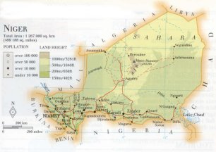
| official name (short form): Niger |
| country code ISO: NE //; - FIPS: NG |
| location: West Africa |
| time zone: +1 UT |
| surface (land) area: 1186408, or: 1267000 sq.km = 458075, or: 489188 sq.mi |
| geographical position in extreme co-ordinates: North: 23° N / South: 12° N / East: 16° E / West: 0° E |
| borders (land): Algeria, Libya, Chad, Nigeria, Benin, Burkina faso, Mali |
| borders (coastline): none |
| climate: tropical arid |
| Government |
| independent since: 1960-08-03 |
| type of government: republic |
| capital: Niamey |
| administrative division: département (7) |
| Population |
| population according to the latest census (1988): 7228,552 |
| total population according to the estimate of midyear 2000: 10075,511; or: 10832,000 /-; 2001: 11030,000 |
| population density: 9 per sq.km = 23,5 per sq.mi |
| population growth: 3% //; - doubling time: 23 years |
| birth rate: 55 per 1000 |
| death rate: 25 per 1000 |
| fertility rate: 7 children per female |
| maternal mortality: 420 per 100,000 |
| infant mortality (1-4 years): 119 per 1000 |
| life expectancy: 42 years (male: 42; female: 41) |
| age breakdown: 0-14 years: 48% //; - 15-59 years: 48% //; - 60+ years: 4% |
| urbanisation: 21% //; - urbanisation growth: 7% |
| percentage of urban population in the greatest city: 31% |
| Ethnic composition, language, religion |
| ethnic groups: Hausa 53%; Djerma 15%; Fula 9%; Kanuri-Nanga 9%; Songhai 8%; Tuareg 3%; other 2% |
| languages: French (official); Hausa, Djerma |
| religious affiliation: Sunnî Muslim 89%; traditional beliefs 11% |
| Health |
| daily food intake: 1966 calories per capita |
| population with access to safe water: 53 - 59% |
| people per physician: 54444 |
| people per hospital bed: |
| Education, literacy |
| school enrolment: primary education 6-11 years: 23% |
| school enrolment: secondary education: 4% |
| school enrolment: tertiary education 20-24 years: < 1% |
| adult literacy: 13,6% (male: 20,9%; female: 6,6%) [later total figure found: 16%] |
| Economy and infrastructure |
| Economy and trade |
| currency: CFA franc = 100 centimes |
| annual inflation rate: 6% |
| population below poverty line: 63% |
| Gross Domestic Product: USD 850 per capita |
| GNI USD 180 per capita //; - [ppp: 740] |
| GDP growth: -1% |
| income: USD 300 per capita |
| import: USD 355 per capita //; - export: USD 312 per capita |
| trade: USD 87 per capita //; - or 40% of GDP |
| trade partners: FR US CI NI ES JP |
| human development index: 0,274 //; - position of the country in the world no.: 161 |
| female labour force: 44% |
| unemployment: % |
| tourism: 0,05 million |
| Economic activities in agriculture, fisheries, industry, mining, services, energy |
| land use: arable land: 3% //; - grass land: 7% //; - wooded area: 2% //; - arid land and desert: ca 85% |
| agriculture: labour force: 85% //; - part of agriculture in GDP: 38% |
| agricultural products: millet, beans, cowpeas, sorghum, cassava, onions, sugarcane, rice, peanuts, cotton |
| livestock (million): asses: 0,6 / camels: 0,4 / cattle: 2,2 / goats: 6,7 / horses: 0,08 / poultry: 20 / sheep: 4,4 |
| fish catch: 11000 metric tonnes |
| industry: labour force: 3% //; - part of industry in GDP: 19% |
| industrial products: food processing and beverages, chemicals, construction materials, textiles |
| mining products: uranium, salt, tin, gypsum. coal, tungsten, iron, calcium |
| CO2 emission per capita: 0,1 |
| services: labour force: 12% //; - part of services in GDP: 43% |
| energy use (kg per capita): 43 |
| electricity use (per capita): |
| annual water use (per capita): 41 |
| Traffic, communication |
| road network: 9863, or: 39970 km //; - of which paved: 8% //; - of which are motorways: 0 km (Trans-Sahara Highway 428 km) |
| vehicles: 5 per 1000 |
| railways: 0 km //; - railways passenger/km: - |
| navigable inland waterways: 300 km |
| ownership telephone: 1,5 - 2 per 1000 |
| ownership radio receivers: 48 - 70 per 1000 |
| ownership tv-sets: 3 - 27 per 1000 |
| newspaper circulation: 1,3 per 1000 |
| persons per post office: 134000 |
| personal computers: 0,5 per 1000 |
| Some physical landmarks |
| mountains: Mont Bagzane 2022 m, Adrar Tamgak 1988, Gréboun 1944 |
| lowest point: ca 150 m near Gaya, at the southernmost tip where the river Niger leaves the country |
| lakes (natural): Lake Chad (its former northeastern tip is situated in the southeast of the country) |
| lakes (artificial reservoirs): |
| lakes (deepest): unknown |
| rivers: Niger |
| canals: none, or unknown |
| waterfalls: none, or unknown |
| caves: longest system: none, or unknown / deepest: |
| islands: none |
| deserts: Sahara |
| other natural features: |
| Additional remarks, especially on the statistical information |
| other important features: |
| apart from physical landmarks most of the above figures are changeable, in most cases they date from the 1990's |
| primary sources used for the general information: |
| BB CA EV PW WA WB WR, and some national statistical yearbooks |
| particulars concerning population data: |
 To the page containing the population growth statistics of the country
 To the page containing the historical population growth statistics of the provinces
 To the page containing urban historical population statistics
 Back to the homepage of this website: POPULATION STATISTICS
Internet website:Latest modification of this page on 2004-02-29 by Jan Lahmeyer
© "populstat" site: Jan Lahmeyer